geojson-minimum-bounding-rectangle
Version:
A library to compute the Minimum Bounding Rectangle of a GeoJSON polygon
55 lines (33 loc) • 2 kB
Markdown


# Minimum Bounding Rectangle for GeoJSON
This Javascript/Typescript library provides 2 methods for calculating the Minimum Bounding Rectangle by area and by width for a given GeoJSON feature or feature collection.
This problem it is solving has many names: Minimum Bounding Rectangle, Minimum Bounding Box, Smallest Surrounding Rectangle, Minimum Area Rectangle...
## Example
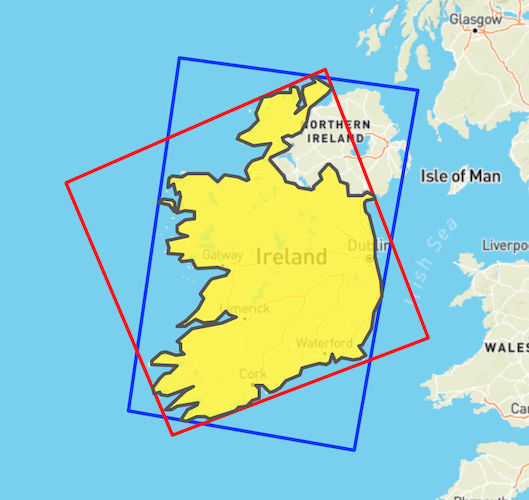
This is an example of the output of this library. The input GeoJSON is the yellow polygon (outline of the Republic of Ireland).
The blue rectangle was generated by ` smallestSurroundingRectangleByWidth` while the red rectangle is the output of ` smallestSurroundingRectangleByArea`
## Changes in version 2
The function of the library is **unchanged**, but all dependencies were updated to turf 7.
The library is now also ES-Modules only.
In case you need CommonJS or compatability with older version of TurfJS, use version 1.0.1
## How to use it
### Installation
```bash
npm install geojson-minimum-bounding-rectangle
```

### Usage
```ts
import {
smallestSurroundingRectangleByWidth,
smallestSurroundingRectangleByArea,
} from 'geojson-minimum-bounding-rectangle';
const boundingRect = smallestSurroundingRectangleByWidth(myGeoJsonInput);
```
## More Information:
- https://en.wikipedia.org/wiki/Minimum_bounding_box_algorithms
- https://gis.stackexchange.com/questions/22895/finding-minimum-area-rectangle-for-given-points
## License
See [LICENSE](https://github.com/matthiasfeist/geojson-minimum-bounding-rectangle/blob/main/LICENSE) for more details.