@arcgis/core
Version:
ArcGIS Maps SDK for JavaScript: A complete 2D and 3D mapping and data visualization API
75 lines (73 loc) • 6.51 kB
TypeScript
import type Color from "../../Color.js";
import type ElevationProfileLine from "./ElevationProfileLine.js";
import type { ElevationProfileLineProperties } from "./ElevationProfileLine.js";
import type { ColorLike } from "../../Color.js";
/** @deprecated since version 5.0. Use the [Elevation Profile component](https://developers.arcgis.com/javascript/latest/references/map-components/components/arcgis-elevation-profile/) or [ElevationProfileLineInput](https://developers.arcgis.com/javascript/latest/references/core/analysis/ElevationProfile/ElevationProfileLineInput/) from [ElevationProfileAnalysis](https://developers.arcgis.com/javascript/latest/references/core/analysis/ElevationProfileAnalysis/) instead. For information on widget deprecation, read about [Esri's move to web components](https://developers.arcgis.com/javascript/latest/components-transition-plan/). */
export interface ElevationProfileLineInputProperties extends ElevationProfileLineProperties {
/**
* Color of the line on the chart and in the view.
*
* @default "#00c8c8"
*/
color?: ColorLike;
/**
* Whether a line visualization representing [elevationSamples](https://developers.arcgis.com/javascript/latest/references/core/widgets/ElevationProfile/ElevationProfileLine/#samples)
* should be added to the [SceneView](https://developers.arcgis.com/javascript/latest/references/core/views/SceneView/). This property doesn't apply to [MapView](https://developers.arcgis.com/javascript/latest/references/core/views/MapView/).
*
* @default false
* @since 4.20
*/
viewVisualizationEnabled?: boolean;
}
/**
* Profile line which samples elevation from the geometry of the input [Graphic](https://developers.arcgis.com/javascript/latest/references/core/Graphic/)
* itself, typically used on input lines with z values. If the input graphic is draped
* ([elevation mode](https://developers.arcgis.com/javascript/latest/references/core/layers/FeatureLayer/#elevationInfo) is "on-the-ground"), the elevation is sampled
* from the [Ground](https://developers.arcgis.com/javascript/latest/references/core/Ground/), in case the scene has ground layers.
*
* In 2D z values are not fetched from feature based layers. Therefore, a profile is generated for
* ElevationProfileLineInput only when the input feature is a client-side graphic with z values
* in a [MapView](https://developers.arcgis.com/javascript/latest/references/core/views/MapView/).
*
* 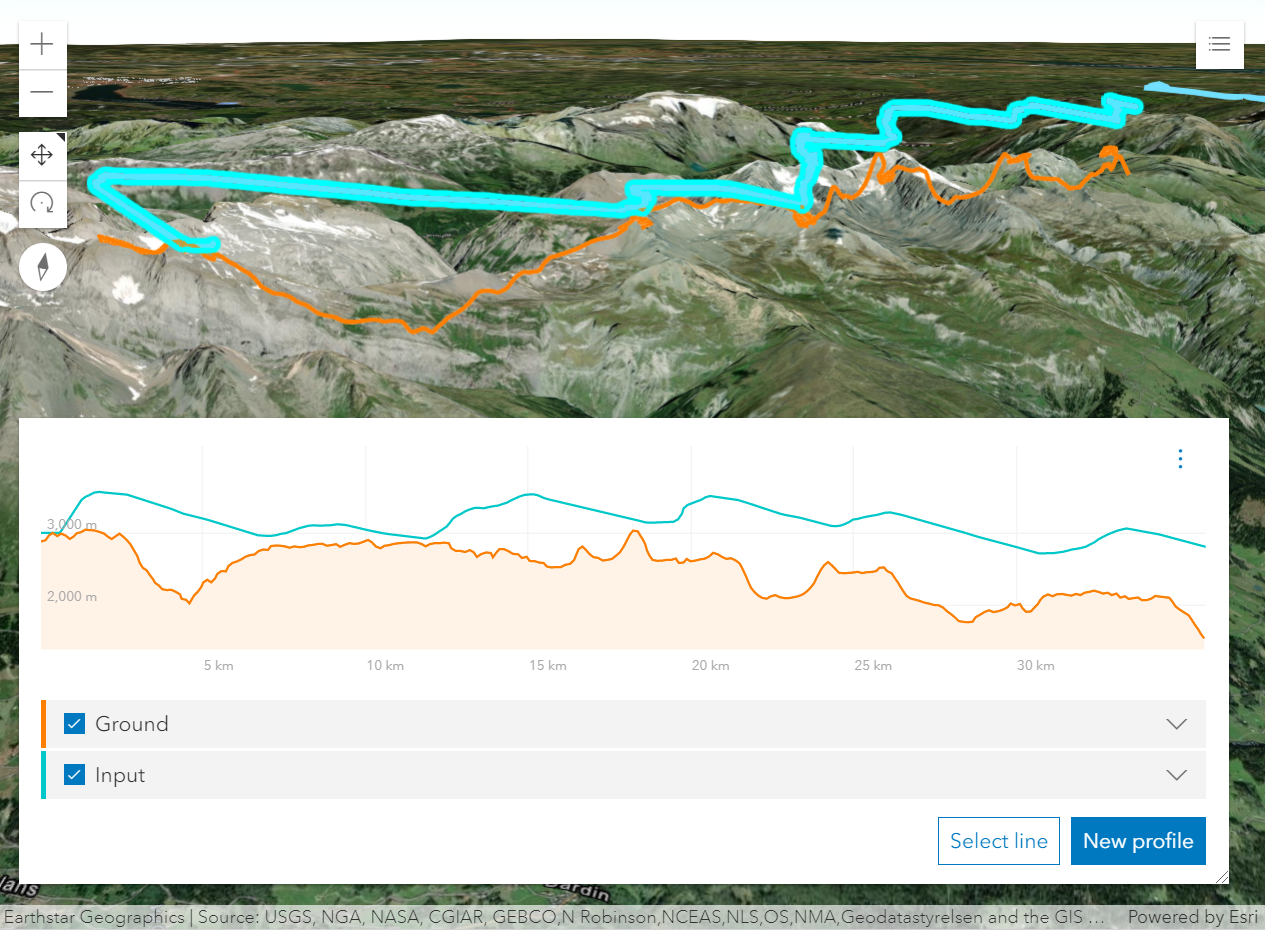
* _Profile generated from a line feature with z-values. The orange profile is created with a profile line of type input._
*
* @deprecated since version 5.0. Use the [Elevation Profile component](https://developers.arcgis.com/javascript/latest/references/map-components/components/arcgis-elevation-profile/) or [ElevationProfileLineInput](https://developers.arcgis.com/javascript/latest/references/core/analysis/ElevationProfile/ElevationProfileLineInput/) from [ElevationProfileAnalysis](https://developers.arcgis.com/javascript/latest/references/core/analysis/ElevationProfileAnalysis/) instead. For information on widget deprecation, read about [Esri's move to web components](https://developers.arcgis.com/javascript/latest/components-transition-plan/).
* @since 4.18
* @see [ElevationProfile](https://developers.arcgis.com/javascript/latest/references/core/widgets/ElevationProfile/) widget - Deprecated since 5.0. Use the [Elevation Profile component](https://developers.arcgis.com/javascript/latest/references/map-components/components/arcgis-elevation-profile/) instead.
* @see [ElevationProfileViewModel](https://developers.arcgis.com/javascript/latest/references/core/widgets/ElevationProfile/ElevationProfileViewModel/) - Deprecated since 5.0. Use [ElevationProfileAnalysis](https://developers.arcgis.com/javascript/latest/references/core/analysis/ElevationProfileAnalysis/) instead.
* @see [ElevationProfileLineGround](https://developers.arcgis.com/javascript/latest/references/core/widgets/ElevationProfile/ElevationProfileLineGround/) - Deprecated since 5.0. Use [ElevationProfileLineGround](https://developers.arcgis.com/javascript/latest/references/core/analysis/ElevationProfile/ElevationProfileLineGround/) from [ElevationProfileAnalysis](https://developers.arcgis.com/javascript/latest/references/core/analysis/ElevationProfileAnalysis/) instead.
* @see [ElevationProfileLineQuery](https://developers.arcgis.com/javascript/latest/references/core/widgets/ElevationProfile/ElevationProfileLineQuery/) - Deprecated since 5.0. Use [ElevationProfileLineQuery](https://developers.arcgis.com/javascript/latest/references/core/analysis/ElevationProfile/ElevationProfileLineQuery/) from [ElevationProfileAnalysis](https://developers.arcgis.com/javascript/latest/references/core/analysis/ElevationProfileAnalysis/) instead.
* @see [ElevationProfileLineView](https://developers.arcgis.com/javascript/latest/references/core/widgets/ElevationProfile/ElevationProfileLineView/) - Deprecated since 5.0. Use [ElevationProfileLineScene](https://developers.arcgis.com/javascript/latest/references/core/analysis/ElevationProfile/ElevationProfileLineScene/) from [ElevationProfileAnalysis](https://developers.arcgis.com/javascript/latest/references/core/analysis/ElevationProfileAnalysis/) instead.
* @example
* const elevationProfile = new ElevationProfile({
* view: view,
* profiles: [{
* type: "input",
* color: "orange"
* }, {
* type: "ground",
* color: "lime"
* }]
* });
*/
export default class ElevationProfileLineInput extends ElevationProfileLine {
constructor(properties?: ElevationProfileLineInputProperties);
/**
* Color of the line on the chart and in the view.
*
* @default "#00c8c8"
*/
get color(): Color;
set color(value: ColorLike);
/** The line type. */
readonly type: "input";
/**
* Whether a line visualization representing [elevationSamples](https://developers.arcgis.com/javascript/latest/references/core/widgets/ElevationProfile/ElevationProfileLine/#samples)
* should be added to the [SceneView](https://developers.arcgis.com/javascript/latest/references/core/views/SceneView/). This property doesn't apply to [MapView](https://developers.arcgis.com/javascript/latest/references/core/views/MapView/).
*
* @default false
* @since 4.20
*/
accessor viewVisualizationEnabled: boolean;
}