@arcgis/core
Version:
ArcGIS Maps SDK for JavaScript: A complete 2D and 3D mapping and data visualization API
228 lines (226 loc) • 13.1 kB
TypeScript
import type DirectLineMeasurementAnalysis from "../analysis/DirectLineMeasurementAnalysis.js";
import type SceneView from "../views/SceneView.js";
import type Widget from "./Widget.js";
import type DirectLineMeasurement3DViewModel from "./DirectLineMeasurement3D/DirectLineMeasurement3DViewModel.js";
import type { Icon } from "@esri/calcite-components/components/calcite-icon";
import type { DirectLineMeasurementAnalysisProperties } from "../analysis/DirectLineMeasurementAnalysis.js";
import type { SystemOrLengthUnit } from "../core/units.js";
import type { WidgetProperties } from "./Widget.js";
import type { DirectLineMeasurement3DViewModelProperties } from "./DirectLineMeasurement3D/DirectLineMeasurement3DViewModel.js";
/** @deprecated since version 4.33. Use the [Direct Line Measurement 3D component](https://developers.arcgis.com/javascript/latest/references/map-components/components/arcgis-direct-line-measurement-3d/) instead. For information on widget deprecation, read about [Esri's move to web components](https://developers.arcgis.com/javascript/latest/components-transition-plan/). */
export interface DirectLineMeasurement3DProperties extends WidgetProperties, Partial<Pick<DirectLineMeasurement3D, "unit" | "unitOptions" | "view">> {
/**
* The direct line measurement analysis object being created or modified by the widget. This property is an
* alias for [DirectLineMeasurement3DViewModel.analysis](https://developers.arcgis.com/javascript/latest/references/core/widgets/DirectLineMeasurement3D/DirectLineMeasurement3DViewModel/#analysis).
*
* If no analysis is provided, the widget automatically creates its own analysis and adds it to the view. In this
* case, the analysis will also be automatically removed from the view when the widget is destroyed.
*
* @since 4.23
* @see [DirectLineMeasurement3DViewModel.analysis](https://developers.arcgis.com/javascript/latest/references/core/widgets/DirectLineMeasurement3D/DirectLineMeasurement3DViewModel/#analysis)
* @example
* // Construct a direct line measurement analysis object outside of the widget
* const analysis = new DirectLineMeasurementAnalysis({
* startPoint: {
* type: "point", // autocasts as new Point()
* x: 7.67,
* y: 45.981,
* z: 3435.765
* },
* endPoint: {
* type: "point",
* x: 7.659,
* y: 45.976,
* z: 4437
* }
* });
*
* // Ensure that the analysis is added to the view
* view.analyses.add(analysis);
*
* // Frame the analysis in the view
* view.goTo(analysis.extent);
*
* // Pass the analysis object as a constructor parameter to modify it using the widget
* const viewModel = new DirectLineMeasurement3D({
* analysis: analysis,
* view: view
* });
*/
analysis?: DirectLineMeasurementAnalysisProperties & { type: "direct-line-measurement"; };
/**
* Icon which represents the widget. It is typically used when the widget is controlled by another
* one (e.g. in the Expand widget).
*
* @default "measure-line"
* @since 4.27
* @see [Calcite Icon Search](https://developers.arcgis.com/calcite-design-system/icons/)
* @see [Calcite Icon Search](https://developers.arcgis.com/calcite-design-system/icons/)
*/
icon?: Icon["icon"] | null;
/**
* The widget's default label.
*
* @since 4.11
*/
label?: string | null;
/**
* The view model for this widget. This is a class that contains all the logic
* (properties and methods) that controls this widget's behavior. See the
* [DirectLineMeasurement3DViewModel](https://developers.arcgis.com/javascript/latest/references/core/widgets/DirectLineMeasurement3D/DirectLineMeasurement3DViewModel/) class to access
* all properties and methods on the widget.
*
* @since 4.7
*/
viewModel?: DirectLineMeasurement3DViewModelProperties;
}
/**
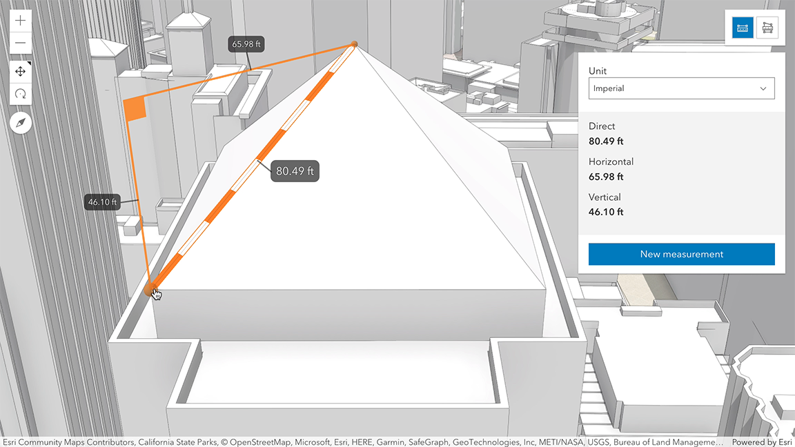
* The DirectLineMeasurement3D widget calculates and displays the 3D distance between two points.
* This widget can be used in a [SceneView](https://developers.arcgis.com/javascript/latest/references/core/views/SceneView/) to measure the vertical, horizontal,
* and direct distance between two points.
*
* [](https://developers.arcgis.com/javascript/latest/sample-code/widgets-measurement-3d/)
*
* How distances are computed depends on the scene's spatial reference.
*
* In **geographic coordinate systems** (GCS) and in **Web Mercator**:
* - Direct distance is computed in a Euclidean manner, in an [ECEF](https://en.wikipedia.org/wiki/ECEF) coordinate system (or equivalent on other planets);
* - Horizontal distance is computed geodetically, taking into consideration the curvature of the planet;
* - Vertical distance is computed as an elevation difference.
*
* In **projected coordinate systems** (PCS), apart from Web Mercator, all three distances (direct, horizontal, and vertical)
* are computed in a Euclidean manner (in their respective PCS).
*
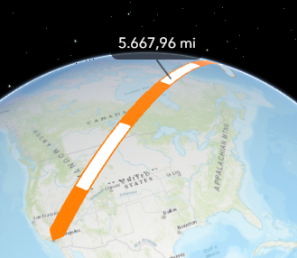
* DirectLineMeasurement3D widget visualizes and labels the direct, horizontal, and vertical distances and displays the same values
* in the UI panel. When the distance between the points is greater than 100 kilometers,
* the measurement visualization is simplified, and only the horizontal and vertical distances are calculated.
* The direct distance option becomes unavailable.
*
* 
*
* When the widget is active, a horizontal "laser" line is drawn which indicates the height at the current mouse position.
* This line can help in analyzing the heights of objects relative to each other and the terrain.
* A second laser line shows the intersection of the scene with the vertical plane that passes through the checkered line.
*
* This widget is designed to work with 3D SceneViews. For measurements with 2D MapViews, use
* [DistanceMeasurement2D](https://developers.arcgis.com/javascript/latest/references/core/widgets/DistanceMeasurement2D/).
*
* > [!WARNING]
* >
* > **Things to consider:**
* > Snapping is enabled by default. This can be temporarily disabled by holding the `CTRL` key.
* > Layer types currently supported for snapping are: [FeatureLayer](https://developers.arcgis.com/javascript/latest/references/core/layers/FeatureLayer/), [GraphicsLayer](https://developers.arcgis.com/javascript/latest/references/core/layers/GraphicsLayer/) (except Mesh geometries),
* > [GeoJSONLayer](https://developers.arcgis.com/javascript/latest/references/core/layers/GeoJSONLayer/), [WFSLayer](https://developers.arcgis.com/javascript/latest/references/core/layers/WFSLayer/), [CSVLayer](https://developers.arcgis.com/javascript/latest/references/core/layers/CSVLayer/),
* > [3D Object SceneLayer](https://developers.arcgis.com/javascript/latest/references/core/layers/SceneLayer/), and [BuildingSceneLayer](https://developers.arcgis.com/javascript/latest/references/core/layers/BuildingSceneLayer/).
*
* @deprecated since version 4.33. Use the [Direct Line Measurement 3D component](https://developers.arcgis.com/javascript/latest/references/map-components/components/arcgis-direct-line-measurement-3d/) instead. For information on widget deprecation, read about [Esri's move to web components](https://developers.arcgis.com/javascript/latest/components-transition-plan/).
* @since 4.6
* @see [Sample - Measurement in 3D](https://developers.arcgis.com/javascript/latest/sample-code/widgets-measurement-3d/)
* @see [Sample - Analysis objects](https://developers.arcgis.com/javascript/latest/sample-code/analysis-objects/)
* @see [Sample - Color theming for interactive tools](https://developers.arcgis.com/javascript/latest/sample-code/view-theme/)
* @see [DirectLineMeasurement3DViewModel](https://developers.arcgis.com/javascript/latest/references/core/widgets/DirectLineMeasurement3D/DirectLineMeasurement3DViewModel/) - _Deprecated since 4.33. Use the [DirectLineMeasurementAnalysis](https://developers.arcgis.com/javascript/latest/references/core/analysis/DirectLineMeasurementAnalysis/) or [Direct Line Measurement component](https://developers.arcgis.com/javascript/latest/references/map-components/components/arcgis-direct-line-measurement-3d/) instead._
* @see [AreaMeasurement3D](https://developers.arcgis.com/javascript/latest/references/core/widgets/AreaMeasurement3D/)
* @see [DefaultUI](https://developers.arcgis.com/javascript/latest/references/core/views/ui/DefaultUI/)
* @see [SceneView.theme](https://developers.arcgis.com/javascript/latest/references/core/views/SceneView/#theme)
* @example
* let measurementWidget = new DirectLineMeasurement3D({
* view: view
* });
*
* view.ui.add(measurementWidget, "top-right");
*/
export default class DirectLineMeasurement3D extends Widget<DirectLineMeasurement3DProperties> {
/**
* @example
* // typical usage
* let measurementWidget = new DirectLineMeasurement3D({
* view: view
* });
*/
constructor(properties?: DirectLineMeasurement3DProperties);
/**
* The direct line measurement analysis object being created or modified by the widget. This property is an
* alias for [DirectLineMeasurement3DViewModel.analysis](https://developers.arcgis.com/javascript/latest/references/core/widgets/DirectLineMeasurement3D/DirectLineMeasurement3DViewModel/#analysis).
*
* If no analysis is provided, the widget automatically creates its own analysis and adds it to the view. In this
* case, the analysis will also be automatically removed from the view when the widget is destroyed.
*
* @since 4.23
* @see [DirectLineMeasurement3DViewModel.analysis](https://developers.arcgis.com/javascript/latest/references/core/widgets/DirectLineMeasurement3D/DirectLineMeasurement3DViewModel/#analysis)
* @example
* // Construct a direct line measurement analysis object outside of the widget
* const analysis = new DirectLineMeasurementAnalysis({
* startPoint: {
* type: "point", // autocasts as new Point()
* x: 7.67,
* y: 45.981,
* z: 3435.765
* },
* endPoint: {
* type: "point",
* x: 7.659,
* y: 45.976,
* z: 4437
* }
* });
*
* // Ensure that the analysis is added to the view
* view.analyses.add(analysis);
*
* // Frame the analysis in the view
* view.goTo(analysis.extent);
*
* // Pass the analysis object as a constructor parameter to modify it using the widget
* const viewModel = new DirectLineMeasurement3D({
* analysis: analysis,
* view: view
* });
*/
get analysis(): DirectLineMeasurementAnalysis;
set analysis(value: DirectLineMeasurementAnalysisProperties & { type: "direct-line-measurement"; });
/**
* Icon which represents the widget. It is typically used when the widget is controlled by another
* one (e.g. in the Expand widget).
*
* @default "measure-line"
* @since 4.27
* @see [Calcite Icon Search](https://developers.arcgis.com/calcite-design-system/icons/)
* @see [Calcite Icon Search](https://developers.arcgis.com/calcite-design-system/icons/)
*/
get icon(): Icon["icon"];
set icon(value: Icon["icon"] | null | undefined);
/**
* The widget's default label.
*
* @since 4.11
*/
get label(): string;
set label(value: string | null | undefined);
/**
* Unit system (imperial, metric) or specific unit used for displaying the distance values.
* Possible values are listed in [unitOptions](https://developers.arcgis.com/javascript/latest/references/core/widgets/DirectLineMeasurement3D/#unitOptions).
*
* @since 4.8
*/
accessor unit: SystemOrLengthUnit;
/**
* List of unit systems (imperial, metric) and specific units for displaying the distance values.
* By default, the following units are included: `metric`, `imperial`, `inches`, `feet`, `us-feet`, `yards`, `miles`, `nautical-miles`, `meters`, `kilometers`.
* Possible [unit](https://developers.arcgis.com/javascript/latest/references/core/widgets/DirectLineMeasurement3D/#unit) values can only be a subset of this list.
*
* @since 4.7
*/
accessor unitOptions: SystemOrLengthUnit[];
/** A reference to the [SceneView](https://developers.arcgis.com/javascript/latest/references/core/views/SceneView/). Set this to link the widget to a specific view. */
accessor view: SceneView | null | undefined;
/**
* The view model for this widget. This is a class that contains all the logic
* (properties and methods) that controls this widget's behavior. See the
* [DirectLineMeasurement3DViewModel](https://developers.arcgis.com/javascript/latest/references/core/widgets/DirectLineMeasurement3D/DirectLineMeasurement3DViewModel/) class to access
* all properties and methods on the widget.
*
* @since 4.7
*/
get viewModel(): DirectLineMeasurement3DViewModel;
set viewModel(value: DirectLineMeasurement3DViewModelProperties);
}