@arcgis/core
Version:
ArcGIS Maps SDK for JavaScript: A complete 2D and 3D mapping and data visualization API
46 lines (44 loc) • 2.53 kB
TypeScript
import type { JSONSupport } from "../../core/JSONSupport.js";
export interface FeatureReductionSelectionProperties {}
/**
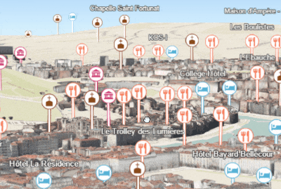
* Declutters points in the [SceneView](https://developers.arcgis.com/javascript/latest/references/core/views/SceneView/) by thinning overlapping features so no features
* intersect on screen. Labeling also respects this option and hides labels
* that would otherwise overlap with the features of this layer.
*
* 
*
* > [!WARNING]
* >
* > **Known Limitations**
* >
* > - Currently only supported in 3D [SceneViews](https://developers.arcgis.com/javascript/latest/references/core/views/SceneView/).
* > - Applies only to non-draped [Icon](https://developers.arcgis.com/javascript/latest/references/core/symbols/IconSymbol3DLayer/) or
* > [Text](https://developers.arcgis.com/javascript/latest/references/core/symbols/TextSymbol3DLayer/) symbol layers and their
* > [callouts](https://developers.arcgis.com/javascript/latest/references/core/symbols/callouts/Callout3D/).
*
* @since 4.14
* @see [Sample: Point styles for cities](https://developers.arcgis.com/javascript/latest/sample-code/visualization-point-styles/)
* @see [CSVLayer.featureReduction](https://developers.arcgis.com/javascript/latest/references/core/layers/CSVLayer/#featureReduction)
* @see [FeatureLayer.featureReduction](https://developers.arcgis.com/javascript/latest/references/core/layers/FeatureLayer/#featureReduction)
* @see [GeoJSONLayer.featureReduction](https://developers.arcgis.com/javascript/latest/references/core/layers/GeoJSONLayer/#featureReduction)
* @see [OGCFeatureLayer.featureReduction](https://developers.arcgis.com/javascript/latest/references/core/layers/OGCFeatureLayer/#featureReduction)
* @see [SceneLayer.featureReduction](https://developers.arcgis.com/javascript/latest/references/core/layers/SceneLayer/#featureReduction)
* @see [StreamLayer.featureReduction](https://developers.arcgis.com/javascript/latest/references/core/layers/StreamLayer/#featureReduction)
* @example
* layer.featureReduction = {
* type: "selection"
* };
*/
export default class FeatureReductionSelection extends JSONSupport {
constructor(properties?: FeatureReductionSelectionProperties);
/**
* The feature reduction type.
*
* @example
* // enables feature reduction by selection
* layer.featureReduction = {
* type: "selection"
* };
*/
get type(): "selection";
}