@arcgis/core
Version:
ArcGIS Maps SDK for JavaScript: A complete 2D and 3D mapping and data visualization API
351 lines (347 loc) • 16.9 kB
TypeScript
import type WebMap from "../WebMap.js";
import type WebScene from "../WebScene.js";
import type Collection from "../core/Collection.js";
import type Widget from "./Widget.js";
import type ListItem from "./TableList/ListItem.js";
import type TableListViewModel from "./TableList/TableListViewModel.js";
import type TableListVisibleElements from "./TableList/TableListVisibleElements.js";
import type { Icon } from "@esri/calcite-components/components/calcite-icon";
import type { IdentifiableMixin, IdentifiableMixinProperties } from "../core/Identifiable.js";
import type { WidgetProperties } from "./Widget.js";
import type { Action } from "./LayerList/types.js";
import type { HeadingLevel } from "./support/types.js";
import type { TableListViewModelEvents, TableListViewModelProperties } from "./TableList/TableListViewModel.js";
import type { ListItemProperties } from "./TableList/ListItem.js";
import type { ReadonlyArrayOrCollection } from "../core/Collection.js";
import type { TableListVisibleElementsProperties } from "./TableList/TableListVisibleElements.js";
export interface TableListProperties extends WidgetProperties, IdentifiableMixinProperties, Partial<Pick<TableList, "collapsed" | "dragEnabled" | "filterPlaceholder" | "filterPredicate" | "filterText" | "headingLevel" | "listItemCreatedFunction" | "map" | "minDragEnabledItems" | "minFilterItems" | "selectionMode">> {
/**
* Icon which represents the widget. It is typically used when the widget is controlled by another
* one (e.g. in the Expand widget).
*
* @default "table"
* @since 4.27
* @see [Calcite Icon Search](https://developers.arcgis.com/calcite-design-system/icons/)
* @see [Calcite Icon Search](https://developers.arcgis.com/calcite-design-system/icons/)
*/
icon?: Icon["icon"] | null;
/**
* The widget's default label.
*
* @since 4.11
*/
label?: string | null;
/**
* A collection of selected [ListItem](https://developers.arcgis.com/javascript/latest/references/core/widgets/TableList/ListItem/)s representing table list items
* selected by the user.
*
* @see [selectionMode](https://developers.arcgis.com/javascript/latest/references/core/widgets/TableList/#selectionMode)
*/
selectedItems?: ReadonlyArrayOrCollection<ListItemProperties>;
/**
* The view model for this widget. This is a class that contains all the logic
* (properties and methods) that controls this widget's behavior. See the
* [TableListViewModel](https://developers.arcgis.com/javascript/latest/references/core/widgets/TableList/TableListViewModel/) class to access
* all properties and methods on the widget.
*/
viewModel?: TableListViewModelProperties;
/**
* The visible elements that are displayed within the widget.
* This property provides the ability to turn individual elements of the widget's display on/off.
*
* @since 4.25
* @example
* tableList.visibleElements = {
* closeButton: false,
* collapseButton: true,
* errors: true,
* filter: true,
* heading: true,
* statusIndicators: true
* };
*/
visibleElements?: TableListVisibleElementsProperties;
}
export interface TableListEvents extends TableListViewModelEvents {}
/**
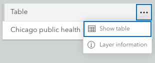
* The TableList widget provides a way to display a list of tables associated with a [Map](https://developers.arcgis.com/javascript/latest/references/core/Map/).
* It is meant to be used with [feature layer](https://developers.arcgis.com/javascript/latest/references/core/layers/FeatureLayer/) tables.
*
* If a map contains feature layer tables, they will display within the widget. Tables can also be added to the
* [Map.tables](https://developers.arcgis.com/javascript/latest/references/core/Map/#tables) collection. Any tables referenced in the [map](https://developers.arcgis.com/javascript/latest/references/core/widgets/TableList/#map)
* property will display in the widget. If unsure of whether the
* layer is a table, check the feature layer's [FeatureLayer.isTable](https://developers.arcgis.com/javascript/latest/references/core/layers/FeatureLayer/#isTable) property.
*
* The [ListItem](https://developers.arcgis.com/javascript/latest/references/core/widgets/TableList/ListItem/) API provides access to each table, allows
* the developer to configure actions related to the table, and allows the developer to add content to the item related to the table.
*
* > [!WARNING]
* >
* > **Known Limitations**
* >
* > The TableList widget is not supported with [web scenes](https://developers.arcgis.com/javascript/latest/references/core/WebScene/).
*
* 
*
* @deprecated since version 5.0. Use the [Table List component](https://developers.arcgis.com/javascript/latest/references/map-components/components/arcgis-table-list/) instead. For information on widget deprecation, read about [Esri's move to web components](https://developers.arcgis.com/javascript/latest/components-transition-plan/).
* @since 4.17
* @see [TableListViewModel](https://developers.arcgis.com/javascript/latest/references/core/widgets/TableList/TableListViewModel/)
* @see [Map.tables](https://developers.arcgis.com/javascript/latest/references/core/Map/#tables)
* @see [WebMap.tables](https://developers.arcgis.com/javascript/latest/references/core/WebMap/#tables)
* @see [Sample - TableList Widget](https://developers.arcgis.com/javascript/latest/sample-code/widgets-tablelist/)
* @example
* const tableList = new TableList({
* map: map, // takes any tables associated with the map and displays in widget
* listItemCreatedFunction: function(event) {
* let item = event.item;
* item.actionsSections = [
* {
* title: "Show table",
* className: "esri-icon-table",
* id: "table",
* type: "toggle"
* },
* {
* title: "Layer information",
* className: "esri-icon-description",
* id: "information"
* }
* ]
* });
*/
export default class TableList extends TableListSuperclass {
/**
* @deprecated
* Do not directly reference this property.
* Use EventNames and EventTypes helpers from \@arcgis/core/Evented
*/
"@eventTypes": TableListEvents;
/**
* @example
* // Typical usage
* const tableList = new TableList({
* map: map
* });
*/
constructor(properties?: TableListProperties);
/**
* Indicates whether the widget is collapsed.
* When collapsed, only the collapse button and heading are displayed.
*
* @default false
* @since 4.29
* @see [visibleElements.collapseButton](https://developers.arcgis.com/javascript/latest/references/core/widgets/TableList/#visibleElements)
* @example tableList.collapsed = true;
*/
accessor collapsed: boolean;
/**
* Indicates whether [list items](https://developers.arcgis.com/javascript/latest/references/core/widgets/TableList/ListItem/) may be reordered within the list by dragging and dropping.
* Drag won't be enabled until the number of list items is equal to or greater than than the value set set in [minDragEnabledItems](https://developers.arcgis.com/javascript/latest/references/core/widgets/TableList/#minDragEnabledItems).
*
* @default false
* @since 4.29
* @see [minDragEnabledItems](https://developers.arcgis.com/javascript/latest/references/core/widgets/TableList/#minDragEnabledItems)
* @example tableList.dragEnabled = true;
*/
accessor dragEnabled: boolean;
/**
* Placeholder text used in the filter input if [visibleElements.filter](https://developers.arcgis.com/javascript/latest/references/core/widgets/TableList/#visibleElements) is true.
*
* @default ""
* @since 4.29
* @see [visibleElements.filter](https://developers.arcgis.com/javascript/latest/references/core/widgets/TableList/#visibleElements)
* @example tableList.filterPlaceholder = "Filter layers";
*/
accessor filterPlaceholder: string;
/**
* Specifies a function to handle filtering [list items](https://developers.arcgis.com/javascript/latest/references/core/widgets/TableList/ListItem/).
*
* @since 4.32
* @example layerList.filterPredicate = (item) => item.title.toLowerCase().includes("streets");
*/
accessor filterPredicate: FilterPredicate | null | undefined;
/**
* The value of the filter input text string if [visibleElements.filter](https://developers.arcgis.com/javascript/latest/references/core/widgets/TableList/#visibleElements) is true.
*
* @default ""
* @since 4.29
* @see [visibleElements.filter](https://developers.arcgis.com/javascript/latest/references/core/widgets/TableList/#visibleElements)
* @example
* reactiveUtils.watch(
* () => tableList.filterText,
* (filterText) => console.log(filterText)
* );
*/
accessor filterText: string;
/**
* Indicates the heading level to use for the [TableListVisibleElements.heading](https://developers.arcgis.com/javascript/latest/references/core/widgets/TableList/TableListVisibleElements/#heading).
* By default, the title is rendered
* as a level 2 heading (e.g. `<h2>Table List</h2>`). Depending on the widget's placement
* in your app, you may need to adjust this heading for proper semantics. This is
* important for meeting accessibility standards.
*
* @default 2
*/
accessor headingLevel: HeadingLevel;
/**
* Icon which represents the widget. It is typically used when the widget is controlled by another
* one (e.g. in the Expand widget).
*
* @default "table"
* @since 4.27
* @see [Calcite Icon Search](https://developers.arcgis.com/calcite-design-system/icons/)
* @see [Calcite Icon Search](https://developers.arcgis.com/calcite-design-system/icons/)
*/
get icon(): Icon["icon"];
set icon(value: Icon["icon"] | null | undefined);
/**
* The widget's default label.
*
* @since 4.11
*/
get label(): string;
set label(value: string | null | undefined);
/**
* Specifies a function that accesses each [ListItem](https://developers.arcgis.com/javascript/latest/references/core/widgets/TableList/ListItem/).
* Each list item can be modified according to its modifiable properties. Actions can be added
* to list items using the [ListItem.actionsSections](https://developers.arcgis.com/javascript/latest/references/core/widgets/TableList/ListItem/#actionsSections)
* property of the ListItem.
*
* @example
* const tableList = new TableList({
* map: map,
* listItemCreatedFunction: (event) => {
* const { item } = event;
* item.actionsSections = [
* [
* {
* title: "Go to full extent",
* icon: "layer-zoom-to",
* id: "full-extent"
* }
* ]
* ];
* }
* });
*/
accessor listItemCreatedFunction: TableListViewModel["listItemCreatedFunction"];
/**
* A reference to a [Map](https://developers.arcgis.com/javascript/latest/references/core/Map/) containing the tables. Set this property
* to access the underlying tables within the map.
*
* @see [Map.tables](https://developers.arcgis.com/javascript/latest/references/core/Map/#tables)
* @see [WebMap.tables](https://developers.arcgis.com/javascript/latest/references/core/WebMap/#tables)
* @example
* Layer.fromPortalItem({
* // Loads a layer (table) from a portal item
* portalItem: { // autocasts new PortalItem()
* id: "add portal item id"
* }
* }).then(function(layer) {
* // Load the layer
* layer.load().then(function() {
* // Check if the layer is a table
* if (layer.isTable) {
* map.tables.add(layer);
* console.log(map.tables);
* }
* });
* });
*
* const tableList = new TableList({
* map: map // map contains tables collection
* });
*/
accessor map: WebMap | WebScene | null | undefined;
/**
* The minimum number of list items required to enable drag and drop reordering with [dragEnabled](https://developers.arcgis.com/javascript/latest/references/core/widgets/TableList/#dragEnabled).
*
* @default 2
* @since 4.29
* @see [dragEnabled](https://developers.arcgis.com/javascript/latest/references/core/widgets/TableList/#dragEnabled)
* @example
* tableList.dragEnabled = true;
* tableList.minDragEnabledItems = 5;
*/
accessor minDragEnabledItems: number;
/**
* The minimum number of list items required to display the [visibleElements.filter](https://developers.arcgis.com/javascript/latest/references/core/widgets/TableList/TableListVisibleElements/) input box.
*
* @default 10
* @since 4.29
* @see [visibleElements.filter](https://developers.arcgis.com/javascript/latest/references/core/widgets/TableList/TableListVisibleElements/)
* @example
* tableList.visibleElements.filter = true;
* tableList.minFilterItems = 5;
*/
accessor minFilterItems: number;
/**
* A collection of selected [ListItem](https://developers.arcgis.com/javascript/latest/references/core/widgets/TableList/ListItem/)s representing table list items
* selected by the user.
*
* @see [selectionMode](https://developers.arcgis.com/javascript/latest/references/core/widgets/TableList/#selectionMode)
*/
get selectedItems(): Collection<ListItem>;
set selectedItems(value: ReadonlyArrayOrCollection<ListItemProperties>);
/**
* Specifies the selection mode.
* Selected items are available in the [selectedItems](https://developers.arcgis.com/javascript/latest/references/core/widgets/TableList/#selectedItems) property.
*
* | Value | Description |
* | ----- | ----------- |
* | multiple | Allows any number of items to be selected at once. This is useful when you want to apply an operation to multiple items at the same time. |
* | none | Disables selection. Use this when you want to prevent selecting items. |
* | single | Allows only one item to be selected at a time. If another item is selected, the previous selection is cleared. This is useful when you want to ensure that a maximum of one item is selected at a time. |
* | single-persist | Allows only one item to be selected at a time and prevents de-selection. Once an item is selected, it remains selected until another item is selected. This is useful when you want to ensure that there is always exactly one selected item. |
*
* @default "none"
* @since 4.29
* @see [selectedItems](https://developers.arcgis.com/javascript/latest/references/core/widgets/TableList/#selectedItems)
* @example tableList.selectionMode = "multiple";
*/
accessor selectionMode: "multiple" | "none" | "single" | "single-persist";
/** The collection of table [ListItem](https://developers.arcgis.com/javascript/latest/references/core/widgets/TableList/ListItem/)s displayed within the widget. */
get tableItems(): Collection<ListItem>;
/**
* The view model for this widget. This is a class that contains all the logic
* (properties and methods) that controls this widget's behavior. See the
* [TableListViewModel](https://developers.arcgis.com/javascript/latest/references/core/widgets/TableList/TableListViewModel/) class to access
* all properties and methods on the widget.
*/
get viewModel(): TableListViewModel;
set viewModel(value: TableListViewModelProperties);
/**
* The visible elements that are displayed within the widget.
* This property provides the ability to turn individual elements of the widget's display on/off.
*
* @since 4.25
* @example
* tableList.visibleElements = {
* closeButton: false,
* collapseButton: true,
* errors: true,
* filter: true,
* heading: true,
* statusIndicators: true
* };
*/
get visibleElements(): TableListVisibleElements;
set visibleElements(value: TableListVisibleElementsProperties);
/**
* Triggers the [@trigger-action](https://developers.arcgis.com/javascript/latest/references/core/widgets/TableList/#event-trigger-action) event and executes
* the given [action](https://developers.arcgis.com/javascript/latest/references/core/support/actions/ActionButton/) or
* [action toggle](https://developers.arcgis.com/javascript/latest/references/core/support/actions/ActionToggle/).
*
* @param action - The action to execute.
* @param item - An item associated with the action.
*/
triggerAction(action: Action, item: ListItem): void;
}
declare const TableListSuperclass: typeof Widget & typeof IdentifiableMixin
/**
* Specifies a function to handle filtering [list items](https://developers.arcgis.com/javascript/latest/references/core/widgets/TableList/ListItem/).
*
* @param item - A list item
* created by the TableList.
*/
export type FilterPredicate = (item: ListItem) => boolean;