@arcgis/core
Version:
ArcGIS Maps SDK for JavaScript: A complete 2D and 3D mapping and data visualization API
172 lines (170 loc) • 9.83 kB
TypeScript
import type SceneView from "../views/SceneView.js";
import type Widget from "./Widget.js";
import type ShadowCastViewModel from "./ShadowCast/ShadowCastViewModel.js";
import type ShadowCastVisibleElements from "./ShadowCast/ShadowCastVisibleElements.js";
import type { Icon } from "@esri/calcite-components/components/calcite-icon";
import type { WidgetProperties } from "./Widget.js";
import type { HeadingLevel } from "./support/types.js";
import type { ShadowCastViewModelProperties } from "./ShadowCast/ShadowCastViewModel.js";
import type { ShadowCastVisibleElementsProperties } from "./ShadowCast/ShadowCastVisibleElements.js";
export interface ShadowCastProperties extends WidgetProperties, Partial<Pick<ShadowCast, "headingLevel" | "view">> {
/**
* Icon which represents the widget. It is typically used when the widget is controlled by another
* one (e.g. in the Expand widget).
*
* @default "measure-building-height-shadow"
* @since 4.27
* @see [Calcite Icon Search](https://developers.arcgis.com/calcite-design-system/icons/)
* @see [Calcite Icon Search](https://developers.arcgis.com/calcite-design-system/icons/)
*/
icon?: Icon["icon"] | null;
/**
* The widget's default label.
*
* @since 4.11
*/
label?: string | null;
/**
* The view model for this widget. This is a class that contains all the logic (properties and methods)
* that controls this widget's behavior. See the [ShadowCastViewModel](https://developers.arcgis.com/javascript/latest/references/core/widgets/ShadowCast/ShadowCastViewModel/)
* class to access all properties and methods on the widget.
*/
viewModel?: ShadowCastViewModelProperties;
/**
* This property provides the ability to display or hide the individual elements of the widget.
*
* @example
* shadowCast.visibleElements = {
* timeRangeSlider: true,
* timezone: true,
* datePicker: true,
* visualizationOptions: true,
* colorPicker: true,
* tooltip: true
* }
*/
visibleElements?: ShadowCastVisibleElementsProperties;
}
/**
* The ShadowCast widget displays the cumulative shadows of 3D features in a
* [SceneView](https://developers.arcgis.com/javascript/latest/references/core/views/SceneView/). This type of analysis is helpful in urban development,
* where new projects have to satisfy certain shadow duration constraints.
*
* The widget calculates the cumulative shadows for a time range during a single day. The user can
* configure the time range and select a calendar date. This time range and calendar date are only used
* for the shadow analysis and are not connected to the lighting in the scene.
* To control the lighting in the scene, the [Daylight](https://developers.arcgis.com/javascript/latest/references/core/widgets/Daylight/) widget can be used.
* Changing the timezone in the widget updates the visualization by interpreting the time range as being
* in that timezone. This behavior is different than for the [Daylight](https://developers.arcgis.com/javascript/latest/references/core/widgets/Daylight/) widget
* where selecting a timezone updates the scene date and time according to the camera position.
*
* The widget provides three visualization modes.
*
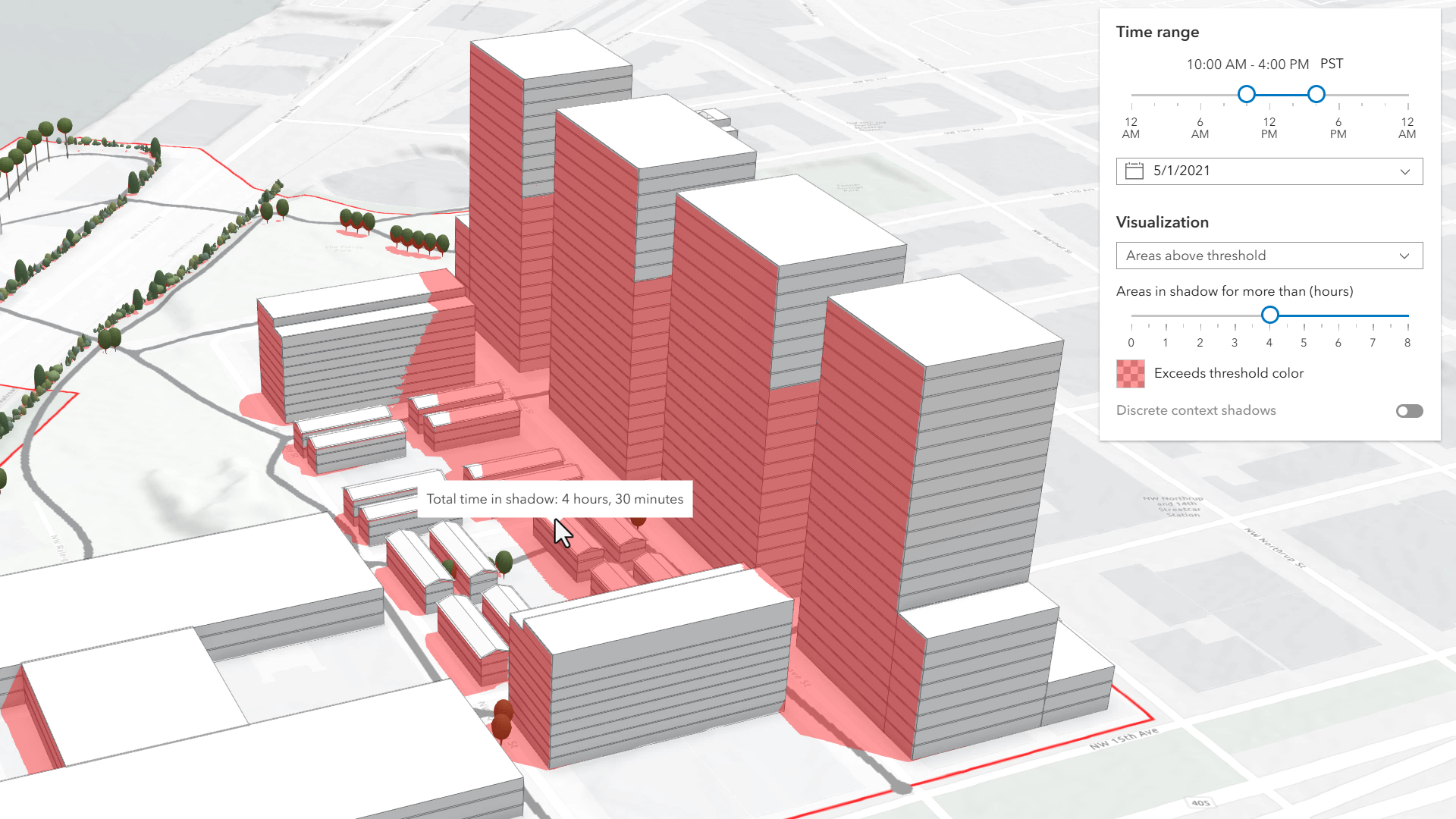
* In the **threshold** mode, only the areas that receive
* shadows for more than a certain amount of time are displayed. In the image below, on May 1, 2021 the red areas receive
* shadow for more than 4 hours within the time interval of 10AM to 4PM.
*
* [](https://developers.arcgis.com/javascript/latest/sample-code/widgets-shadow-cast/)
*
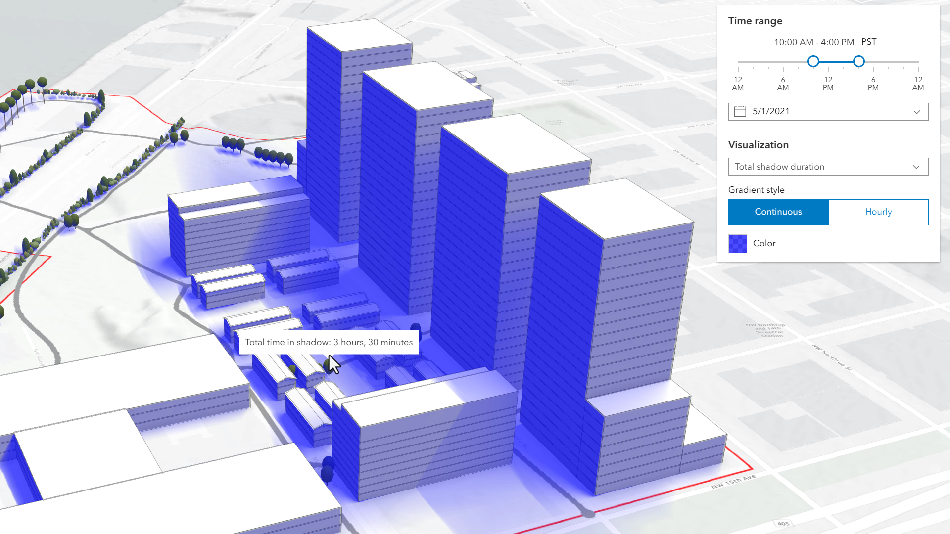
* **Total shadow duration** mode displays the duration of the cumulative shadow using opacity: areas that don't
* receive any shadow are fully transparent and areas that receive a maximum amount of shadow have a default opacity
* of 0.7. The values in between are interpolated. Hovering over the view will display a tooltip showing the
* amount of time that location is in shadow, rounded to 15 minute intervals. In this mode, the visualization
* can display shadow cast in a continuous way or in 1 hour intervals.
*
* [](https://developers.arcgis.com/javascript/latest/sample-code/widgets-shadow-cast/)
*
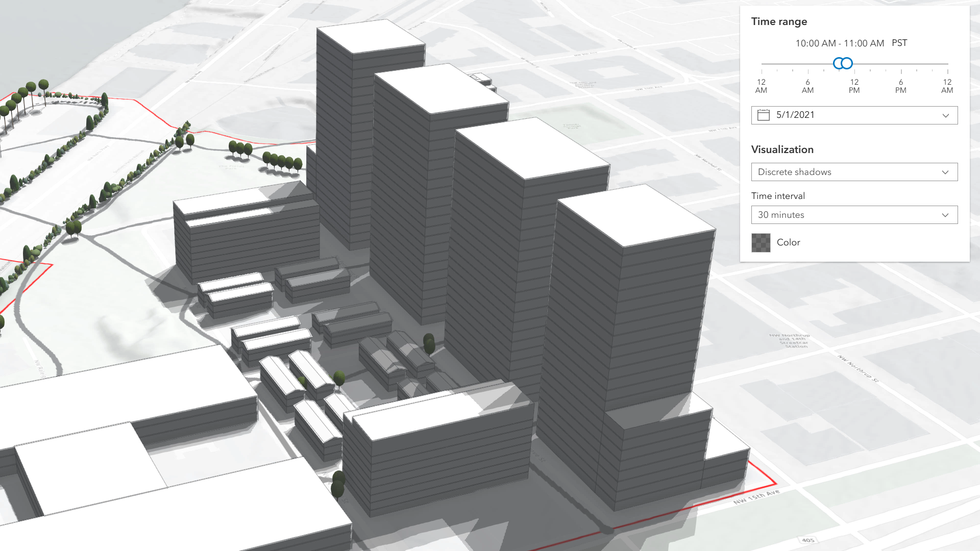
* **Discrete shadows** is a third visualization mode which displays individual shadows at a given time interval.
* For example, setting the time range to 10AM-11AM and the visualization time interval to 30 minutes will display
* shadows for 10AM, 10:30AM and 11:00AM.
*
* [](https://developers.arcgis.com/javascript/latest/sample-code/widgets-shadow-cast/)
*
* The defaults for the time range and visualization settings can be changed using the
* [ShadowCastViewModel](https://developers.arcgis.com/javascript/latest/references/core/widgets/ShadowCast/ShadowCastViewModel/).
*
* > [!WARNING]
* >
* > **Known Limitations**
* >
* > Terrain does not cast shadows and it is therefore not taken into account in this analysis.
* >
* > The widget does not take into account the daylight savings.
* > Use the timezone dropdown to adjust the offset from the Coordinated Universal Time (UTC) and account for the daylight saving time.
* >
* > The timezone is automatically detected by the widget based on the camera location. In some situations this might not be accurate.
* > In case of an inaccurate timezone, users can set it manually using the timezone dropdown.
*
* You can use the view's [DefaultUI](https://developers.arcgis.com/javascript/latest/references/core/views/ui/DefaultUI/) to add widgets to the view's user interface via the
* `ui` property on the view. See the example below.
*
* @deprecated since version 5.0. Use the [Shadow Cast component](https://developers.arcgis.com/javascript/latest/references/map-components/components/arcgis-shadow-cast/) instead. For information on widget deprecation, read about [Esri's move to web components](https://developers.arcgis.com/javascript/latest/components-transition-plan/).
* @since 4.21
* @see [ShadowCastViewModel](https://developers.arcgis.com/javascript/latest/references/core/widgets/ShadowCast/ShadowCastViewModel/) - _Deprecated since 5.0. Use the [ShadowCastAnalysis](https://developers.arcgis.com/javascript/latest/references/core/analysis/ShadowCastAnalysis/) or [Shadow Cast component](https://developers.arcgis.com/javascript/latest/references/map-components/components/arcgis-shadow-cast/) instead._
* @see [SceneView.environment](https://developers.arcgis.com/javascript/latest/references/core/views/SceneView/#environment)
* @see [DefaultUI](https://developers.arcgis.com/javascript/latest/references/core/views/ui/DefaultUI/)
* @see [Sample - Shadow cast](https://developers.arcgis.com/javascript/latest/sample-code/widgets-shadow-cast/)
* @example
* const shadowCast = new ShadowCast({
* view: view
* });
* // Adds the shadow cast widget in
* // the top right corner of the view
* view.ui.add(shadowCast, "top-right");
*/
export default class ShadowCast extends Widget {
constructor(properties?: ShadowCastProperties);
/**
* Indicates the heading level to use for the titles "Time range" and "Visualization". By default, this message is rendered
* as level 4 headings (e.g. `<h4>Time range</h4>`). Depending on the widget's placement
* in your app, you may need to adjust this heading for proper semantics. This is
* important for meeting accessibility standards.
*
* @default 4
* @see [Heading Elements](https://developer.mozilla.org/en-US/docs/Web/HTML/Element/Heading_Elements)
* @example shadowCast.headingLevel = 3;
*/
accessor headingLevel: HeadingLevel;
/**
* Icon which represents the widget. It is typically used when the widget is controlled by another
* one (e.g. in the Expand widget).
*
* @default "measure-building-height-shadow"
* @since 4.27
* @see [Calcite Icon Search](https://developers.arcgis.com/calcite-design-system/icons/)
* @see [Calcite Icon Search](https://developers.arcgis.com/calcite-design-system/icons/)
*/
get icon(): Icon["icon"];
set icon(value: Icon["icon"] | null | undefined);
/**
* The widget's default label.
*
* @since 4.11
*/
get label(): string;
set label(value: string | null | undefined);
/** A reference to the [View](https://developers.arcgis.com/javascript/latest/references/core/views/View/). This widget is only supported in a [SceneView](https://developers.arcgis.com/javascript/latest/references/core/views/SceneView/). */
accessor view: SceneView | null | undefined;
/**
* The view model for this widget. This is a class that contains all the logic (properties and methods)
* that controls this widget's behavior. See the [ShadowCastViewModel](https://developers.arcgis.com/javascript/latest/references/core/widgets/ShadowCast/ShadowCastViewModel/)
* class to access all properties and methods on the widget.
*/
get viewModel(): ShadowCastViewModel;
set viewModel(value: ShadowCastViewModelProperties);
/**
* This property provides the ability to display or hide the individual elements of the widget.
*
* @example
* shadowCast.visibleElements = {
* timeRangeSlider: true,
* timezone: true,
* datePicker: true,
* visualizationOptions: true,
* colorPicker: true,
* tooltip: true
* }
*/
get visibleElements(): ShadowCastVisibleElements;
set visibleElements(value: ShadowCastVisibleElementsProperties);
}