@arcgis/core
Version:
ArcGIS Maps SDK for JavaScript: A complete 2D and 3D mapping and data visualization API
188 lines (184 loc) • 9.43 kB
TypeScript
import type Layer from "../layers/Layer.js";
import type Sublayer from "../layers/support/Sublayer.js";
import type Widget from "./Widget.js";
import type ScaleRangeSliderViewModel from "./ScaleRangeSlider/ScaleRangeSliderViewModel.js";
import type { Icon } from "@esri/calcite-components/components/calcite-icon";
import type { MapViewOrSceneView } from "../views/MapViewOrSceneView.js";
import type { SupportedRegion } from "./ScaleRangeSlider/types.js";
import type { ScaleRangeSliderViewModelProperties } from "./ScaleRangeSlider/ScaleRangeSliderViewModel.js";
import type { WidgetProperties } from "./Widget.js";
export interface ScaleRangeSliderProperties extends WidgetProperties, Partial<Pick<ScaleRangeSlider, "disabled" | "layer" | "maxScale" | "maxScaleLimit" | "minScale" | "minScaleLimit" | "mode" | "region" | "showWorldValue" | "view" | "visibleElements">> {
/**
* Icon displayed in the widget's button.
*
* @default "actual-size"
* @since 4.27
* @see [Calcite Icon Search](https://developers.arcgis.com/calcite-design-system/icons/)
* @see [Calcite Icon Search](https://developers.arcgis.com/calcite-design-system/icons/)
*/
icon?: Icon["icon"] | null;
/**
* The widget's default label.
*
* @since 4.11
*/
label?: string | null;
/**
* The view model for this widget. This is a class that contains all the logic
* (properties and methods) that controls this widget's behavior. See the
* [ScaleRangeSliderViewModel](https://developers.arcgis.com/javascript/latest/references/core/widgets/ScaleRangeSlider/ScaleRangeSliderViewModel/) class to access
* all properties and methods on the widget.
*/
viewModel?: ScaleRangeSliderViewModelProperties;
}
/**
* The visible elements that are displayed within the widget.
* This provides the ability to turn individual elements of the widget's display on/off.
*/
export interface VisibleElements {
/**
* Indicates whether the preview thumbnail of the scale is visible.
* Default value is `true`.
*/
preview?: boolean;
/**
* Indicates whether the scale dropdown menus are visible.
*
* @since 4.24
*/
scaleMenus?: boolean | VisibleElementsScaleMenus;
}
export interface VisibleElementsScaleMenus {
/** Indicates whether the minimum scale dropdown menu is visible. Default value is `true`. */
minScaleMenu?: boolean;
/** Indicates whether the maximum scale dropdown menu is visible. Default value is `true`. */
maxScaleMenu?: boolean;
}
/**
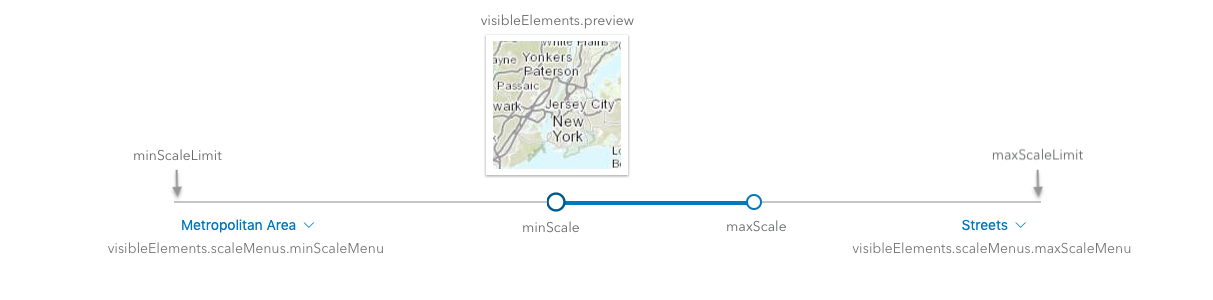
* The ScaleRangeSlider widget allows the user to set a minimum and maximum scale based on named scale ranges.
* When a layer is provided to the widget, the [minScale](https://developers.arcgis.com/javascript/latest/references/core/widgets/ScaleRangeSlider/#minScale) and [maxScale](https://developers.arcgis.com/javascript/latest/references/core/widgets/ScaleRangeSlider/#maxScale) are set to the
* scale range of the layer.
*
* The user can update the scale range by dragging thumbs across the slider to update the minScale and maxScale.
* The user can also change the `minScale` and `maxScale` by using the dropdowns underneath the [minScaleLimit](https://developers.arcgis.com/javascript/latest/references/core/widgets/ScaleRangeSlider/#minScaleLimit)
* and [maxScaleLimit](https://developers.arcgis.com/javascript/latest/references/core/widgets/ScaleRangeSlider/#maxScaleLimit). The thumbnail shows a preview of the scale based on the [region](https://developers.arcgis.com/javascript/latest/references/core/widgets/ScaleRangeSlider/#region) specified.
*
* 
*
* @deprecated since version 5.0. Use the [Scale Range Slider component](https://developers.arcgis.com/javascript/latest/references/map-components/components/arcgis-scale-range-slider/) instead. For information on widget deprecation, read about [Esri's move to web components](https://developers.arcgis.com/javascript/latest/components-transition-plan/).
* @since 4.13
* @see [ScaleRangeSliderViewModel](https://developers.arcgis.com/javascript/latest/references/core/widgets/ScaleRangeSlider/ScaleRangeSliderViewModel/)
* @see [ScaleRanges](https://developers.arcgis.com/javascript/latest/references/core/widgets/ScaleRangeSlider/ScaleRanges/)
* @see [Slider](https://developers.arcgis.com/javascript/latest/references/core/widgets/Slider/)
* @example
* const scaleRangeSlider = new ScaleRangeSlider({
* view: view,
* layer: featureLayer, // scale range of this layer sets initial minScale and maxScale
* region: "MX", // preview thumbnail will be of Mexico
* });
* view.ui.add(scaleRangeSlider, "bottom-left");
*
* // to update the featureLayer min/max scale based on the slider
* reactiveUtils.watch(
* () => [scaleRangeSlider.minScale, scaleRangeSlider.maxScale],
* ([minScale, maxScale]) => {
* featureLayer.minScale = minScale;
* featureLayer.maxScale = maxScale;
* }
* );
*/
export default class ScaleRangeSlider extends Widget {
constructor(properties?: ScaleRangeSliderProperties);
/**
* When `true`, sets the widget to a disabled state so the user cannot interact with it.
*
* @default false
*/
accessor disabled: boolean;
/**
* Icon displayed in the widget's button.
*
* @default "actual-size"
* @since 4.27
* @see [Calcite Icon Search](https://developers.arcgis.com/calcite-design-system/icons/)
* @see [Calcite Icon Search](https://developers.arcgis.com/calcite-design-system/icons/)
*/
get icon(): Icon["icon"];
set icon(value: Icon["icon"] | null | undefined);
/**
* The widget's default label.
*
* @since 4.11
*/
get label(): string;
set label(value: string | null | undefined);
/**
* When provided, the initial [minScale](https://developers.arcgis.com/javascript/latest/references/core/widgets/ScaleRangeSlider/#minScale) and [maxScale](https://developers.arcgis.com/javascript/latest/references/core/widgets/ScaleRangeSlider/#maxScale) values will match the layer's.
*
* When a tiled layer is used, the slider will be restricted from moving the slider thumbs past the `lods` of the layer's tiling scheme.
* Since version 4.28, when a [MapImageLayer](https://developers.arcgis.com/javascript/latest/references/core/layers/MapImageLayer/) is used, the slider will be restricted from moving past the min/max scale defined on the map service.
* The unavailable range will be designated with a dashed line.
*/
accessor layer: Layer | Sublayer | null | undefined;
/**
* The maximum scale of the active scale range. When the maxScale
* reaches the [maxScaleLimit](https://developers.arcgis.com/javascript/latest/references/core/widgets/ScaleRangeSlider/#maxScaleLimit), the maxScale
* value becomes 0 and there is no maximum scale set.
*/
accessor maxScale: number;
/** The lowest possible maximum scale value on the slider. */
accessor maxScaleLimit: number;
/**
* The minimum scale of the active scale range. When the minScale
* reaches the [minScaleLimit](https://developers.arcgis.com/javascript/latest/references/core/widgets/ScaleRangeSlider/#minScaleLimit), the minScale
* value becomes 0 and there is no minimum scale.
*/
accessor minScale: number;
/** The highest possible minimum scale value on the slider. */
accessor minScaleLimit: number;
/**
* The mode of the widget, indicating which slider thumbs can be adjusted.
*
* @default "range"
* @since 4.29
*/
accessor mode: "range" | "max-scale-only" | "min-scale-only";
/**
* The region that the scale thumbnails will focus on.
* Each region comes from the [ISO 3166-1 alpha-2 code](https://en.wikipedia.org/wiki/List_of_ISO_3166_country_codes).
* See [SupportedRegion](https://developers.arcgis.com/javascript/latest/references/core/widgets/ScaleRangeSlider/types/#SupportedRegion) for the list of regions that are currently supported.
*
* @default "US"
*/
accessor region: SupportedRegion;
/**
* Indicates whether the world scale value is shown in the scale menu.
*
* @default false
* @since 4.34
*/
accessor showWorldValue: boolean;
/**
* A reference to the [MapView](https://developers.arcgis.com/javascript/latest/references/core/views/MapView/) or [SceneView](https://developers.arcgis.com/javascript/latest/references/core/views/SceneView/).
* Set this to link the widget to a specific view.
*/
accessor view: MapViewOrSceneView | null | undefined;
/**
* The view model for this widget. This is a class that contains all the logic
* (properties and methods) that controls this widget's behavior. See the
* [ScaleRangeSliderViewModel](https://developers.arcgis.com/javascript/latest/references/core/widgets/ScaleRangeSlider/ScaleRangeSliderViewModel/) class to access
* all properties and methods on the widget.
*/
get viewModel(): ScaleRangeSliderViewModel;
set viewModel(value: ScaleRangeSliderViewModelProperties);
/**
* The visible elements that are displayed within the widget.
* This property provides the ability to turn individual elements of the widget's display on/off.
*
* @example
* scaleRangeSlider.visibleElements = {
* preview: false // thumbnail preview of map will not be displayed
* }
*/
accessor visibleElements: VisibleElements;
}