@arcgis/core
Version:
ArcGIS Maps SDK for JavaScript: A complete 2D and 3D mapping and data visualization API
274 lines (271 loc) • 14.3 kB
TypeScript
import type Widget from "./Widget.js";
import type FeatureTemplatesViewModel from "./FeatureTemplates/FeatureTemplatesViewModel.js";
import type TemplateItem from "./FeatureTemplates/TemplateItem.js";
import type VisibleElements from "./FeatureTemplates/VisibleElements.js";
import type { Icon } from "@esri/calcite-components/components/calcite-icon";
import type { FeatureTemplatesViewModelEvents, FeatureTemplatesViewModelProperties } from "./FeatureTemplates/FeatureTemplatesViewModel.js";
import type { Filter, GroupByType } from "./FeatureTemplates/types.js";
import type { HeadingLevel } from "./support/types.js";
import type { VisibleElementsProperties } from "./FeatureTemplates/VisibleElements.js";
import type { WidgetProperties } from "./Widget.js";
export interface FeatureTemplatesProperties extends WidgetProperties, Partial<Pick<FeatureTemplates, "disabled" | "enableListScroll" | "filterFunction" | "filterText" | "groupBy" | "headingLevel" | "layers" | "selectionMode">> {
/**
* Icon displayed in the widget's button.
*
* @default "list-rectangle"
* @since 4.27
* @see [Calcite Icon Search](https://developers.arcgis.com/calcite-design-system/icons/)
* @see [Calcite Icon Search](https://developers.arcgis.com/calcite-design-system/icons/)
*/
icon?: Icon["icon"] | null;
/**
* The widget's default label.
*
* @since 4.11
*/
label?: string | null;
/**
* The view model for this widget. This is a class that contains all the logic
* (properties and methods) that controls this widget's behavior. See the
* [FeatureTemplatesViewModel](https://developers.arcgis.com/javascript/latest/references/core/widgets/FeatureTemplates/FeatureTemplatesViewModel/) class to access
* all properties and methods on the widget.
*/
viewModel?: FeatureTemplatesViewModelProperties;
/**
* The visible elements that are displayed within the widget.
* This property provides the ability to turn individual elements of the widget's display on/off.
*
* 
*
* @since 4.15
* @example
* featureTemplates.visibleElements = {
* filter: false
* };
*/
visibleElements?: VisibleElementsProperties;
}
export interface FeatureTemplatesEvents extends FeatureTemplatesViewModelEvents {}
/**
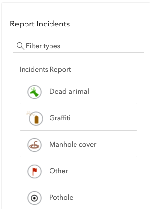
* The FeatureTemplates widget is part of the overall editing workflow. Its main purpose is to display
* [FeatureLayer.templates](https://developers.arcgis.com/javascript/latest/references/core/layers/FeatureLayer/#templates) from one or more [feature layers](https://developers.arcgis.com/javascript/latest/references/core/layers/FeatureLayer/).
* In addition to displaying feature layer templates, it is also possible to [filter](https://developers.arcgis.com/javascript/latest/references/core/widgets/FeatureTemplates/#filterFunction) and [group](https://developers.arcgis.com/javascript/latest/references/core/widgets/FeatureTemplates/#groupBy) templates
* for an easier editing experience. The widget listens for an end user to select a specific [template](https://developers.arcgis.com/javascript/latest/references/core/widgets/FeatureTemplates/TemplateItem/)
* in the widget. Its [@select](https://developers.arcgis.com/javascript/latest/references/core/widgets/FeatureTemplates/#event-select)
* event is fired and the resulting template information is returned. This widget can be used in conjunction with
* [FeatureLayer.applyEdits()](https://developers.arcgis.com/javascript/latest/references/core/layers/FeatureLayer/#applyEdits) to enable an end user to
* update one of its feature layers.
*
* [](https://developers.arcgis.com/javascript/latest/sample-code/editing-applyedits/)
*
* @deprecated since version 5.0. Use the [Feature Templates (Legacy)](https://developers.arcgis.com/javascript/latest/references/map-components/components/arcgis-feature-templates-legacy/) component instead. For information on widget deprecation, read about [Esri's move to web components](https://developers.arcgis.com/javascript/latest/components-transition-plan/).
* @since 4.10
* @see [Sample - Update FeatureLayer using ApplyEdits](https://developers.arcgis.com/javascript/latest/sample-code/editing-applyedits/)
* @see [FeatureTemplatesViewModel](https://developers.arcgis.com/javascript/latest/references/core/widgets/FeatureTemplates/FeatureTemplatesViewModel/)
* @see [TemplateItem](https://developers.arcgis.com/javascript/latest/references/core/widgets/FeatureTemplates/TemplateItem/)
* @see [TemplateItemGroup](https://developers.arcgis.com/javascript/latest/references/core/widgets/FeatureTemplates/TemplateItemGroup/)
* @see [DefaultUI](https://developers.arcgis.com/javascript/latest/references/core/views/ui/DefaultUI/)
* @see [FeatureLayer](https://developers.arcgis.com/javascript/latest/references/core/layers/FeatureLayer/)
* @see [FeatureTemplate](https://developers.arcgis.com/javascript/latest/references/core/layers/support/FeatureTemplate/)
* @example
* const templates = new FeatureTemplates({
* container: "templatesDiv",
* layers: layers
* });
*/
export default class FeatureTemplates extends Widget {
/**
* @deprecated
* Do not directly reference this property.
* Use EventNames and EventTypes helpers from \@arcgis/core/Evented
*/
"@eventTypes": FeatureTemplatesEvents;
/**
* @example
* // Typical usage
* const templates = new FeatureTemplates({
* container: "templatesDiv",
* layers: layers
* });
*/
constructor(properties?: FeatureTemplatesProperties);
/**
* Used to disable the widget user interface. This does not prevent the widget or
* view model from functioning programmatically. Methods invoked programmatically
* still work as expected.
*
* @default false
* @since 4.28
*/
accessor disabled: boolean;
/**
* Indicates whether the list of available feature [template items](https://developers.arcgis.com/javascript/latest/references/core/widgets/FeatureTemplates/TemplateItem/) should scroll within its containing element.
*
* @default true
* @since 4.28
*/
accessor enableListScroll: boolean;
/**
* [function](https://developers.arcgis.com/javascript/latest/references/core/widgets/FeatureTemplates/types/#Filter) can be defined to help filter
* [template items](https://developers.arcgis.com/javascript/latest/references/core/widgets/FeatureTemplates/TemplateItem/) within the widget.
* A custom function can be used to aid when searching for templates. It takes a function which passes in
* an object containing a [name](https://developers.arcgis.com/javascript/latest/references/core/widgets/FeatureTemplates/TemplateItem/#label)
* property of the [template item](https://developers.arcgis.com/javascript/latest/references/core/widgets/FeatureTemplates/TemplateItem/).
*
* 
*
* @example
* // Filter and display templates only if their labels contain the word `Street`
* function myFilterFunction(filter) {
* let containsName = filter.label.includes("Street");
* return containsName;
* }
*
* // Create the FeatureTemplates widget
* templates = new FeatureTemplates({
* container: "templatesDiv",
* visibleElements: {
* filter: false, // disable the default filter UI
* },
* layers: [featureLayer], // in this example, one layer is used
* filterFunction: myFilterFunction
* });
*/
accessor filterFunction: Filter | null | undefined;
/**
* Text used to filter items.
*
* @default ""
*/
accessor filterText: string;
/**
* It is possible to group [template items](https://developers.arcgis.com/javascript/latest/references/core/widgets/FeatureTemplates/TemplateItem/). This can aid
* in managing various template items and how they display within the widget. The values are discussed below.
*
* Type | Description | Example
* ----- | ----------- | -------
* layer | This is the *default* grouping. Groups template items by layers. | 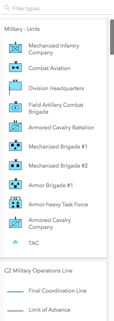
* geometry | Groups template items by geometry type. | 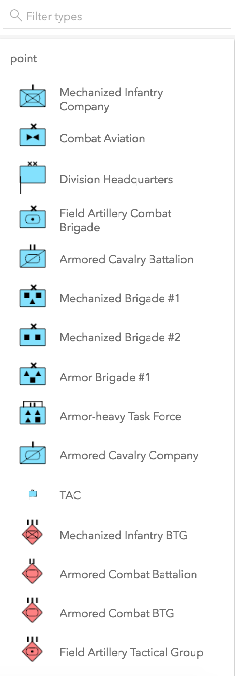
* none | The widget displays everything in one list with no grouping. | 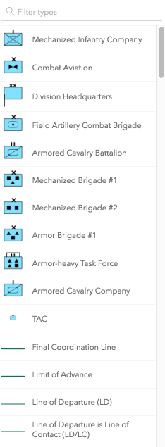
* [GroupByFunction](https://developers.arcgis.com/javascript/latest/references/core/widgets/FeatureTemplates/types/#GroupByFunction) | Custom function that takes an object containing a [FeatureTemplate](https://developers.arcgis.com/javascript/latest/references/core/layers/support/FeatureTemplate/) and [FeatureLayer](https://developers.arcgis.com/javascript/latest/references/core/layers/FeatureLayer/). | 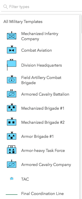
*
* @default "layer"
* @example
* // This example shows using a function to check if
* // the layer title contains the word 'military'. If so,
* // return a group of items called "All Military Templates"
* function customGroup(grouping) {
* // Consolidate all military layers
* if (grouping.layer.title.toLowerCase().indexOf("military") > -1) {
* return "All Military Templates"
* }
* // Otherwise, group by layer title
* return grouping.layer.title;
* }
*
* // Create the FeatureTemplates widget
* templates = new FeatureTemplates({
* container: "templatesDiv",
* layers: layers,
* groupBy: customGroup
* });
*/
accessor groupBy: GroupByType | null | undefined;
/**
* Indicates the heading level to use for the labels of grouped feature templates.
* By default, the group label is rendered
* as a level 4 heading (e.g. `<h4>Group label</h4>`). Depending on the widget's placement
* in your app, you may need to adjust this heading for proper semantics. This is
* important for meeting accessibility standards.
*
* @default 4
* @since 4.20
* @see [Heading Elements](https://developer.mozilla.org/en-US/docs/Web/HTML/Element/Heading_Elements)
* @example
* // Group label will render as an <h3>
* featureTemplates.headingLevel = 3;
*/
accessor headingLevel: HeadingLevel;
/**
* Icon displayed in the widget's button.
*
* @default "list-rectangle"
* @since 4.27
* @see [Calcite Icon Search](https://developers.arcgis.com/calcite-design-system/icons/)
* @see [Calcite Icon Search](https://developers.arcgis.com/calcite-design-system/icons/)
*/
get icon(): Icon["icon"];
set icon(value: Icon["icon"] | null | undefined);
/**
* The widget's default label.
*
* @since 4.11
*/
get label(): string;
set label(value: string | null | undefined);
/**
* An array of [FeatureLayers](https://developers.arcgis.com/javascript/latest/references/core/layers/FeatureLayer/)
* to display within the widget. The order in which these layers are
* set in the array dictates how they display within the widget.
*
* > [!WARNING]
* >
* > The widget is designed to only display layers that are enabled for editing.
* > It will not display layers that are enabled to only edit attributes.
*
* @example
* // The layers to display within the widget
* let militaryUnits = new FeatureLayer({
* url: "http://sampleserver6.arcgisonline.com/arcgis/rest/services/Military/FeatureServer/2"
* });
*
* let militaryHostile = new FeatureLayer({
* url: "http://sampleserver6.arcgisonline.com/arcgis/rest/services/Military/FeatureServer/6"
* });
*
* let layers = [militaryUnits, militaryHostile];
*
* // Create FeatureTemplates widget
* templates = new FeatureTemplates({
* container: "templatesDiv",
* layers: layers
* });
*/
accessor layers: FeatureTemplatesViewModel["layers"];
/**
* Specifies the selection behavior of list items. The `"single"` selection mode keeps the clicked list item selected. Whereas, `"none"` does not preserve the selection after clicking the list item.
*
* @default "none"
* @since 4.28
*/
accessor selectionMode: "single" | "none" | null | undefined;
/**
* The view model for this widget. This is a class that contains all the logic
* (properties and methods) that controls this widget's behavior. See the
* [FeatureTemplatesViewModel](https://developers.arcgis.com/javascript/latest/references/core/widgets/FeatureTemplates/FeatureTemplatesViewModel/) class to access
* all properties and methods on the widget.
*/
get viewModel(): FeatureTemplatesViewModel;
set viewModel(value: FeatureTemplatesViewModelProperties);
/**
* The visible elements that are displayed within the widget.
* This property provides the ability to turn individual elements of the widget's display on/off.
*
* 
*
* @since 4.15
* @example
* featureTemplates.visibleElements = {
* filter: false
* };
*/
get visibleElements(): VisibleElements;
set visibleElements(value: VisibleElementsProperties);
/**
* Selects the [template item](https://developers.arcgis.com/javascript/latest/references/core/widgets/FeatureTemplates/TemplateItem/) to use.
*
* @param item - The [template item](https://developers.arcgis.com/javascript/latest/references/core/widgets/FeatureTemplates/TemplateItem/) to select.
* @see [select event](https://developers.arcgis.com/javascript/latest/references/core/widgets/FeatureTemplates/#event-select)
*/
select(item: TemplateItem | null | undefined): void;
}