@arcgis/core
Version:
ArcGIS Maps SDK for JavaScript: A complete 2D and 3D mapping and data visualization API
126 lines (124 loc) • 6.3 kB
TypeScript
import type Color from "../Color.js";
import type Symbol3DLayer from "./Symbol3DLayer.js";
import type { WaterBodySize, WaveStrength } from "./types.js";
import type { ColorLike } from "../Color.js";
import type { Symbol3DLayerProperties } from "./Symbol3DLayer.js";
export interface WaterSymbol3DLayerProperties extends Symbol3DLayerProperties, Partial<Pick<WaterSymbol3DLayer, "waterbodySize" | "waveDirection" | "waveStrength">> {
/**
* The dominant color used to shade the water. The water has different shades of the dominant color based
* on the reflection of the light. The image below shows how different types of water can be represented with
* different colors. For example for deep water the dominant color could be navy blue.
*
* 
*
* The color can be autocast with an array of rgb(a) values, named string, hex string or an hsl(a) string,
* an object with `r`, `g`, `b`, and `a` properties, or a [Color](https://developers.arcgis.com/javascript/latest/references/core/Color/) object.
*
* @default "#0077be"
* @example
* // a new color by a HEX string
* symbolLayer.color = "#005b66";
*/
color?: ColorLike;
}
/**
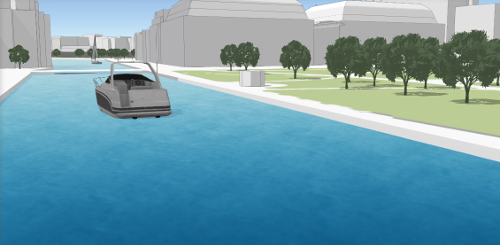
* WaterSymbol3DLayer is used to render [Polygon](https://developers.arcgis.com/javascript/latest/references/core/geometry/Polygon/) geometries as realistic, animated water surfaces,
* therefore it can only be used inside a [PolygonSymbol3D](https://developers.arcgis.com/javascript/latest/references/core/symbols/PolygonSymbol3D/).
*
* 
*
* Various properties can be set to enhance the realistic effect of this symbol layer. The [waveStrength](https://developers.arcgis.com/javascript/latest/references/core/symbols/WaterSymbol3DLayer/#waveStrength)
* can be set to show the magnitude of the waves and [waveDirection](https://developers.arcgis.com/javascript/latest/references/core/symbols/WaterSymbol3DLayer/#waveDirection) indicates
* the direction in which the waves travel. The [waterbodySize](https://developers.arcgis.com/javascript/latest/references/core/symbols/WaterSymbol3DLayer/#waterbodySize) can be set to specify how large the waterbody is.
* The dominant [color](https://developers.arcgis.com/javascript/latest/references/core/symbols/WaterSymbol3DLayer/#color) of the water can be used to change the appearance of the water.
*
* This symbol layer is not supported in a [MapView](https://developers.arcgis.com/javascript/latest/references/core/views/MapView/).
*
* @since 4.12
* @see [Realistic water visualization in 3D](https://developers.arcgis.com/javascript/latest/sample-code/visualization-realistic-water/)
* @example
* const waterLayer = new FeatureLayer({
* ...,
* renderer: {
* type: "simple",
* symbol: {
* type: "polygon-3d",
* symbolLayers: [{
* type: "water",
* waveDirection: 180,
* color: "#5975a3",
* waveStrength: "moderate",
* waterbodySize: "small"
* }]
* }
* }
* });
*/
export default class WaterSymbol3DLayer extends Symbol3DLayer {
constructor(properties?: WaterSymbol3DLayerProperties);
/**
* The dominant color used to shade the water. The water has different shades of the dominant color based
* on the reflection of the light. The image below shows how different types of water can be represented with
* different colors. For example for deep water the dominant color could be navy blue.
*
* 
*
* The color can be autocast with an array of rgb(a) values, named string, hex string or an hsl(a) string,
* an object with `r`, `g`, `b`, and `a` properties, or a [Color](https://developers.arcgis.com/javascript/latest/references/core/Color/) object.
*
* @default "#0077be"
* @example
* // a new color by a HEX string
* symbolLayer.color = "#005b66";
*/
get color(): Color;
set color(value: ColorLike);
/** The symbol type. */
get type(): "water";
/**
* Indicates the size of the waterbody which is represented by the
* symbol layer. `small` can be set for small lakes,
* rivers or swimming pools, `medium` can be set for large lakes,
* whereas `large` is recommended for ocean and sea waterbodies.
*
* @default "medium"
* @example
* // sets the waterBodySize for an ocean like waterbody.
* symbolLayer.waterbodySize = "large";
*/
accessor waterbodySize: WaterBodySize;
/**
* Indicates the direction in which the waves travel. This value represents the geographic rotation in degrees and it ranges from
* 0 to 360 degrees.
* A value of 0 degrees corresponds to geographic north, which means that the wave travels from south to north.
*
* The default is set to `null`, which will display the waves without a distinct direction.
*
* @example
* // sets the wave direction to 215 degrees
* symbolLayer.waveDirection = 215;
*/
accessor waveDirection: number | null | undefined;
/**
* Indicates the shape and intensity of the waves. Currently only calm to moderate waterbodies can be represented.
* A `calm` wave strength represents water without waves, acting almost like a mirror. A water with `rippled` wave strength
* has very small and short waves. `slight` wave strength displays the waves with a more pronounced form, but they are still quite short.
* Choosing `moderate` will display waves with a longer form and a slightly increased intensity.
*
* @default "moderate"
* @example
* // sets the wave strength to small waves
* symbolLayer.waveStrength = "slight";
*/
accessor waveStrength: WaveStrength;
/**
* Creates a deep clone of the symbol layer.
*
* @returns A deep clone of the object that
* invoked this method.
* @example
* // Creates a deep clone of the graphic's first symbol layer
* let symLyr = graphic.symbol.symbolLayers.at(0).clone();
*/
clone(): WaterSymbol3DLayer;
}