@arcgis/core
Version:
ArcGIS Maps SDK for JavaScript: A complete 2D and 3D mapping and data visualization API
269 lines (267 loc) • 11.4 kB
TypeScript
import type Font from "./Font.js";
import type Symbol3DLayer from "./Symbol3DLayer.js";
import type OccludedVisibility from "./support/OccludedVisibility.js";
import type Symbol3DHalo from "./support/Symbol3DHalo.js";
import type Symbol3DMaterial from "./support/Symbol3DMaterial.js";
import type Symbol3DTextBackground from "./support/Symbol3DTextBackground.js";
import type { TextVerticalAlignment, TextHorizontalAlignment } from "./types.js";
import type { OccludedVisibilityProperties } from "./support/OccludedVisibility.js";
import type { Symbol3DHaloProperties } from "./support/Symbol3DHalo.js";
import type { Symbol3DMaterialProperties } from "./support/Symbol3DMaterial.js";
import type { Symbol3DTextBackgroundProperties } from "./support/Symbol3DTextBackground.js";
import type { FontProperties } from "./Font.js";
import type { Symbol3DLayerProperties } from "./Symbol3DLayer.js";
export interface TextSymbol3DLayerProperties extends Symbol3DLayerProperties, Partial<Pick<TextSymbol3DLayer, "horizontalAlignment" | "lineHeight" | "text" | "verticalAlignment">> {
/**
* The background of the text. The background can be used to define a background color for the
* text to improve readability by increasing contrast with the background. Setting a background
* will add additional padding to the text and display using rounded corners.
*
* @example symbolLayer.background = { color: [0, 0, 0, 0.75] };
*/
background?: Symbol3DTextBackgroundProperties | null;
/** The font of the text label. */
font?: FontProperties | null;
/**
* The halo surrounding the text.
*
* @since 4.4
* @example
* symbolLayer.halo = {
* color: [255, 255, 255, 0.8], // autocasts as Color
* size: 2
* }
*/
halo?: Symbol3DHaloProperties | null;
/**
* The material used to color the text.
*
* @example
* // CSS color string
* symbolLayer.material = {
* color: "dodgerblue"
* };
* @example
* // HEX string
* symbolLayer.material = {
* color: "#33cc33";
* }
* @example
* // array of RGBA values
* symbolLayer.material = {
* color: [51, 204, 51, 0.3];
* }
* @example
* // object with rgba properties
* symbolLayer.material = {
* color: { r: 51, g: 51, b: 204, a: 0.7 }
* };
*/
material?: Symbol3DMaterialProperties | null;
/**
* Defines the occluded visibility mode of the text.
*
* @since 5.0
*/
occludedVisibility?: OccludedVisibilityProperties | null;
/**
* Size of the text label in points. This value may be autocast with a string
* expressing size in points or pixels (e.g. `12px`). When set, this property
* overrides the [Font.size](https://developers.arcgis.com/javascript/latest/references/core/symbols/Font/#size) property.
*
* @default 9
* @example
* // size in points
* symbolLayer.size = 14;
* @example
* // size in pixels
* symbolLayer.size = "20px"; // autocasts as number
* @example
* // size in points
* symbolLayer.size = "14pt"; // autocasts as number
*/
size?: number | string;
}
/**
* TextSymbol3DLayer is used to draw text labels for features of any geometry type. This is typically done
* by adding it to a [LabelSymbol3D](https://developers.arcgis.com/javascript/latest/references/core/symbols/LabelSymbol3D/) in a 3D [SceneView](https://developers.arcgis.com/javascript/latest/references/core/views/SceneView/).
* [MapView](https://developers.arcgis.com/javascript/latest/references/core/views/MapView/) does not support 3D symbols.
*
* The color of the symbol is set in the [material](https://developers.arcgis.com/javascript/latest/references/core/symbols/TextSymbol3DLayer/#material) property. The size of the text is
* always defined in points or pixels via the [size](https://developers.arcgis.com/javascript/latest/references/core/symbols/TextSymbol3DLayer/#size) property.
*
* A TextSymbol3DLayer may be added to the `symbolLayers` property of any
* [3D symbol](https://developers.arcgis.com/javascript/latest/references/core/symbols/Symbol3D/). Labeling the features of a
* [FeatureLayer](https://developers.arcgis.com/javascript/latest/references/core/layers/FeatureLayer/) is usually done by adding a TextSymbol3DLayer
* to a [LabelSymbol3D](https://developers.arcgis.com/javascript/latest/references/core/symbols/LabelSymbol3D/), which is then added to a
* [LabelClass](https://developers.arcgis.com/javascript/latest/references/core/layers/support/LabelClass/) in the
* [FeatureLayer.labelingInfo](https://developers.arcgis.com/javascript/latest/references/core/layers/FeatureLayer/#labelingInfo) property of the layer.
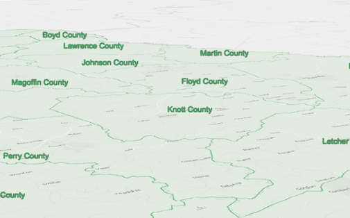
* The image below depicts a [FeatureLayer](https://developers.arcgis.com/javascript/latest/references/core/layers/FeatureLayer/) with labels defined
* by a [LabelSymbol3D](https://developers.arcgis.com/javascript/latest/references/core/symbols/LabelSymbol3D/) that contains a TextSymbol3DLayer.
*
* 
*
* @since 4.0
* @see [Symbol Builder](https://developers.arcgis.com/javascript/latest/symbol-builder/)
* @see [FeatureLayer](https://developers.arcgis.com/javascript/latest/references/core/layers/FeatureLayer/)
* @see [LabelClass](https://developers.arcgis.com/javascript/latest/references/core/layers/support/LabelClass/)
* @see [Sample - Flat vs. volumetric 3D symbol layers](https://developers.arcgis.com/javascript/latest/sample-code/symbols-points-3d/)
* @see [Sample - Line markers and label placement](https://developers.arcgis.com/javascript/latest/sample-code/visualization-line-markers/)
* @see [Sample - Query Elevation (points)](https://developers.arcgis.com/javascript/latest/sample-code/elevation-query-points/)
* @example
* let labelClass = new LabelClass({
* labelExpressionInfo: {
* expression: "$feature.COUNTY" // Text for labels comes from COUNTY field
* },
* symbol: {
* type: "label-3d", // autocasts as new LabelSymbol3D()
* symbolLayers: [{
* type: "text", // autocasts as new TextSymbol3DLayer()
* material: { color: [ 49,163,84 ] },
* size: 12 // points
* }]
* }
* });
* // Add labels to the feature layer
* featureLayer.labelsVisible = true;
* featureLayer.labelingInfo = [ labelClass ];
*/
export default class TextSymbol3DLayer extends Symbol3DLayer {
constructor(properties?: TextSymbol3DLayerProperties);
/**
* The background of the text. The background can be used to define a background color for the
* text to improve readability by increasing contrast with the background. Setting a background
* will add additional padding to the text and display using rounded corners.
*
* @example symbolLayer.background = { color: [0, 0, 0, 0.75] };
*/
get background(): Symbol3DTextBackground | null | undefined;
set background(value: Symbol3DTextBackgroundProperties | null | undefined);
/** The font of the text label. */
get font(): Font | null | undefined;
set font(value: FontProperties | null | undefined);
/**
* The halo surrounding the text.
*
* @since 4.4
* @example
* symbolLayer.halo = {
* color: [255, 255, 255, 0.8], // autocasts as Color
* size: 2
* }
*/
get halo(): Symbol3DHalo | null | undefined;
set halo(value: Symbol3DHaloProperties | null | undefined);
/**
* Adjusts the horizontal alignment of the text in multi-lines.
*
* > [!WARNING]
* >
* > **Known Limitations**
* >
* > This property only applies when the symbol layer is not used for labeling purposes. The `horizontalAlignment` for labels
* > is inferred from the [LabelClass.labelPlacement](https://developers.arcgis.com/javascript/latest/references/core/layers/support/LabelClass/#labelPlacement) value.
* > If the symbol layer is added to a symbol with a [line callout](https://developers.arcgis.com/javascript/latest/references/core/symbols/callouts/LineCallout3D/)
* > or [vertical offset](https://developers.arcgis.com/javascript/latest/references/core/symbols/PointSymbol3D/#verticalOffset), then only `center` is supported.
*
* @default "center"
* @since 4.23
*/
accessor horizontalAlignment: TextHorizontalAlignment;
/**
* The height of the space between each line of text. Only applies to multiline text.
*
* This property can be considered as a multiplier of the default value of 1.0
* (e.g. a value of 2.0 will be two times the height of the default height).
* The range of possible values is: 0.1 - 4.0.
* If a value of 0 is specified, the default value of 1.0 will be used.
*
* @default 1.0
* @since 4.23
*/
accessor lineHeight: number;
/**
* The material used to color the text.
*
* @example
* // CSS color string
* symbolLayer.material = {
* color: "dodgerblue"
* };
* @example
* // HEX string
* symbolLayer.material = {
* color: "#33cc33";
* }
* @example
* // array of RGBA values
* symbolLayer.material = {
* color: [51, 204, 51, 0.3];
* }
* @example
* // object with rgba properties
* symbolLayer.material = {
* color: { r: 51, g: 51, b: 204, a: 0.7 }
* };
*/
get material(): Symbol3DMaterial | null | undefined;
set material(value: Symbol3DMaterialProperties | null | undefined);
/**
* Defines the occluded visibility mode of the text.
*
* @since 5.0
*/
get occludedVisibility(): OccludedVisibility | null | undefined;
set occludedVisibility(value: OccludedVisibilityProperties | null | undefined);
/**
* Size of the text label in points. This value may be autocast with a string
* expressing size in points or pixels (e.g. `12px`). When set, this property
* overrides the [Font.size](https://developers.arcgis.com/javascript/latest/references/core/symbols/Font/#size) property.
*
* @default 9
* @example
* // size in points
* symbolLayer.size = 14;
* @example
* // size in pixels
* symbolLayer.size = "20px"; // autocasts as number
* @example
* // size in points
* symbolLayer.size = "14pt"; // autocasts as number
*/
get size(): number;
set size(value: number | string);
/**
* The text to be displayed. To manually create a new line, use the `\n` escape character.
*
* @example symbolLayer.text = "You are here";
* @example symbolLayer.text = "Wish you were \n here";
*/
accessor text: string | null | undefined;
/** The symbol type. */
get type(): "text";
/**
* Adjusts the vertical alignment of the text.
*
* > [!WARNING]
* >
* > **Known Limitations**
* >
* > This property only applies when the symbol layer is not used for labeling purposes. The `verticalAlignment` for labels
* > is inferred from the [LabelClass.labelPlacement](https://developers.arcgis.com/javascript/latest/references/core/layers/support/LabelClass/#labelPlacement) value.
*
* @default "baseline"
* @since 4.23
*/
accessor verticalAlignment: TextVerticalAlignment;
/**
* Creates a deep clone of the symbol layer.
*
* @returns A deep clone of the object that
* invoked this method.
* @example
* // Creates a deep clone of the graphic's first symbol layer
* const symbolLayer = graphic.symbol.symbolLayers.at(0).clone();
*/
clone(): TextSymbol3DLayer;
}