@arcgis/core
Version:
ArcGIS Maps SDK for JavaScript: A complete 2D and 3D mapping and data visualization API
122 lines (120 loc) • 5.87 kB
TypeScript
import type { JSONSupport } from "../../core/JSONSupport.js";
import type { RasterPixelType } from "../raster/types.js";
export interface RasterFunctionProperties extends Partial<Pick<RasterFunction, "functionArguments" | "functionName" | "outputPixelType" | "rasterFunctionDefinition" | "variableName">> {}
/**
* Raster functions specify processing to be done to the image service. They allow the mosaic image service to deliver a dynamically mosaicked
* image and they can be used to enhance the mosaicked image product by applying processing operations such as image enhancements, and image algebra.
* See [raster functions](https://developers.arcgis.com/documentation/common-data-types/raster-function-objects.htm)
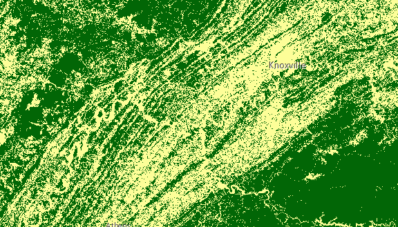
* for a list of functions and their [arguments](https://developers.arcgis.com/javascript/latest/references/core/layers/support/RasterFunction/#functionArguments). The following image shows a landcover ImageryLayer rendered with two chained
* client-side raster functions used to reclass pixel values (Remap) and assign each pixel a new color (Colormap).
*
* [](https://developers.arcgis.com/javascript/latest/sample-code/layers-imagery-rasterfunction/)
*
* Chaining raster functions is accomplished by setting the Raster argument in the [functionArguments](https://developers.arcgis.com/javascript/latest/references/core/layers/support/RasterFunction/#functionArguments) property to another
* defined raster function. See example below on chaining a Remap raster function with a Colormap.
*
* ```js
* let remapRF = new RasterFunction();
* remapRF.functionName = "Remap";
* remapRF.functionArguments = {
* InputRanges: [-3,10,11,37], // remap pixels with values -3 to 10 to now have value of 1
* OutputValues: [1,2], // remap pixel values from 11 to 37 to have a value of 2
* Raster: "$$" // Apply remap to the image service
* };
* remapRF.outputPixelType = "u8";
*
* let colorRF = new RasterFunction();
* colorRF.functionName = "Colormap";
* colorRF.functionArguments = {
* Colormap: [
* [1, 255, 0, 0], // Symbolize pixels with value of 1 using red color
* [2, 0, 255, 0] // Symbolize pixels with value of 2 using green color
* ],
* Raster : remapRF // Apply Colormap to output raster from the remap rasterFunction
* };
*
* imageLayer.rasterFunction = colorRF;
* ```
*
* The following code snippet shows how convenience methods from the [rasterFunctionUtils](https://developers.arcgis.com/javascript/latest/references/core/layers/support/rasterFunctionUtils/) module can be used
* when applying a raster function to an imagery or imagery tile layer.
*
* ```js
* // apply NDVI and colormap raster function to an imagery tile layer
* // use rasterFunctionUtils convenience methods to create raster functions
* const ndvi = rasterFunctionUtils.bandArithmeticNDVI({
* nirBandId: 4,
* redBandId: 3,
* scientificOutput: false
* });
*
* const colormap = rasterFunctionUtils.colormap({
* colorRampName: "NDVI3",
* raster: ndvi
* });
* layer.rasterFunction = colormap;
* ```
*
* @since 4.0
* @see [Sample - Set a server side raster function](https://developers.arcgis.com/javascript/latest/sample-code/layers-imagery-popup/)
* @see [Sample - ImageryLayer raster function](https://developers.arcgis.com/javascript/latest/sample-code/layers-imagery-rasterfunction/)
* @see [Sample - Work with pixelFilter in an ImageryLayer](https://developers.arcgis.com/javascript/latest/sample-code/layers-imagery-pixelvalues/)
* @see [REST API - Raster functions](https://developers.arcgis.com/documentation/common-data-types/raster-function-objects.htm)
* @see [rasterFunctionUtils](https://developers.arcgis.com/javascript/latest/references/core/layers/support/rasterFunctionUtils/)
*/
export default class RasterFunction extends JSONSupport {
constructor(properties?: RasterFunctionProperties);
/**
* The arguments for the raster function. The structure depends on the function specified.
* See [raster functions](https://developers.arcgis.com/documentation/common-data-types/raster-function-objects.htm)
* for a list of functions and their arguments.
* Also parses the arguments of RFT format.
*
* @example
* rasterFunction.functionArguments = {
* "Azimuth":215.0,
* "Altitude":75.0,
* "ZFactor":0.3
* };
*/
accessor functionArguments: Record<string, any>;
/**
* The raster function name.
* See [raster functions](https://developers.arcgis.com/documentation/common-data-types/raster-function-objects.htm)
* for a list of functions and their arguments. The name in the raster function in RFT JSON format is also parsed to functionName.
*
* @example
* rasterFunction.functionName = "Stretched";
* rasterFunction.name = "GrayScale";
*/
accessor functionName: string | null | undefined;
/**
* Defines the pixel type of the output image.
*
* @default "unknown"
* @example rasterFunction.outputPixelType = "u8";
*/
outputPixelType: RasterPixelType;
/**
* Property where Raster Function template is passed.
* RasterFunction template definition created by Raster Function Editor in MapViewer.
*/
accessor rasterFunctionDefinition: any | null | undefined;
/**
* The variable name for the raster function.
*
* @example rasterFunction.variableName = "DEM";
*/
accessor variableName: string | null | undefined;
/**
* Creates a deep clone of the raster function.
*
* @returns A deep clone of the object that
* invoked this method.
* @since 4.29
* @example
* // Creates a deep clone of the layer's rasterFunction
* let rasterFunction = layer.rasterFunction.clone();
*/
clone(): RasterFunction;
}