@arcgis/core
Version:
ArcGIS Maps SDK for JavaScript: A complete 2D and 3D mapping and data visualization API
89 lines (87 loc) • 4.71 kB
TypeScript
import type { JSONSupport } from "../../core/JSONSupport.js";
export interface DimensionalDefinitionProperties extends Partial<Pick<DimensionalDefinition, "dimensionName" | "isSlice" | "values" | "variableName">> {}
/**
* A dimensional definition defines a filter based on one variable and one dimension. You can filter multidimensional data with one or multiple dimensional slices. Instances of this class
* are typically used when filtering data based on [slices](https://developers.arcgis.com/javascript/latest/references/core/layers/support/DimensionalDefinition/#isSlice) or ranges in one or more dimensions by setting
* [MosaicRule.multidimensionalDefinition](https://developers.arcgis.com/javascript/latest/references/core/layers/support/MosaicRule/#multidimensionalDefinition) on an [ImageryLayer.mosaicRule](https://developers.arcgis.com/javascript/latest/references/core/layers/ImageryLayer/#mosaicRule) or
* the [ImageryTileLayer.multidimensionalDefinition](https://developers.arcgis.com/javascript/latest/references/core/layers/ImageryTileLayer/#multidimensionalDefinition) on an ImageryTileLayer.
*
* For example, a single ImageryLayer may have a `depth` dimension storing sea temperatures for the same pixel location at various depths. Another dimension
* could be `time` where the same pixel stores multiple values based on a window of time.
*
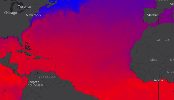
* The snippet in the image below renders sea temperature at the surface for a specific time in the year.
*
* ```js
* let multidimensionalDefinition = [];
* multidimensionalDefinition.push(new DimensionalDefinition({
* variableName: "water_temp",
* dimensionName: "StdZ", // water depth
* values: [0], // sea surface or 0ft
* isSlice: true
* }));
*
* let mosaicRule = new MosaicRule();
* mosaicRule.multidimensionalDefinition = multidimensionalDefinition;
* ```
*
* [](https://developers.arcgis.com/javascript/latest/sample-code/layers-imagery-pixelvalues/)
*
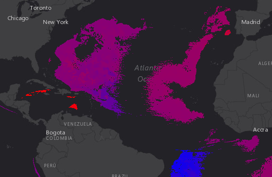
* In contrast, the following image renders sea temperature data from the same service
* at 5000 meters below the surface within the same time window.
*
* ```js
* let multidimensionalDefinition = [];
* multidimensionalDefinition.push(new DimensionalDefinition({
* variableName: "water_temp",
* dimensionName: "StdZ", // water depth
* values: [-5000], // 5000 m below
* isSlice: true
* }));
*
* let mosaicRule = new MosaicRule();
* mosaicRule.multidimensionalDefinition = multidimensionalDefinition;
* ```
*
* [](https://developers.arcgis.com/javascript/latest/sample-code/layers-imagery-pixelvalues/)
*
* @since 4.0
* @see [ImageryLayer - working with multidimensional raster data](https://developers.arcgis.com/javascript/latest/references/core/layers/ImageryLayer/#multidimensionaldata)
* @see [ImageryTileLayer - working with multidimensional raster data](https://developers.arcgis.com/javascript/latest/references/core/layers/ImageryTileLayer/#multidimensionaldata)
* @see [MosaicRule](https://developers.arcgis.com/javascript/latest/references/core/layers/support/MosaicRule/)
* @see [Sample - Work with pixelFilter in an ImageryLayer](https://developers.arcgis.com/javascript/latest/sample-code/layers-imagery-pixelvalues/)
* @see [Sample - Multidimensional ImageryTileLayer](https://developers.arcgis.com/javascript/latest/sample-code/layers-imagery-multidimensional/)
*/
export default class DimensionalDefinition extends JSONSupport {
constructor(properties?: DimensionalDefinitionProperties);
/** The dimension associated with the variable. */
accessor dimensionName: string;
/**
* Indicates whether the values indicate slices (rather than ranges).
*
* @default false
*/
accessor isSlice: boolean;
/**
* An array of single values or tuples [min, max] each defining a range of
* valid values along the specified dimension.
*
* @example
* // -10 is the minimum valid value and 10 is the maximum valid value
* definition.values = [[-10, 10]];
*/
accessor values: (number | [
number,
number
])[];
/** The required variable name by which to filter. */
accessor variableName: string;
/**
* Creates a clone of the DimensionalDefinition object.
*
* @returns A clone of the object that invoked this method.
* @example
* // Creates a clone of the DimensionalDefinition
* let dimensionalDefinition1 = dimensionalDefinition.clone();
*/
clone(): DimensionalDefinition;
}