@arcgis/core
Version:
ArcGIS Maps SDK for JavaScript: A complete 2D and 3D mapping and data visualization API
601 lines (598 loc) • 24.2 kB
TypeScript
import type Color from "../Color.js";
import type Extent from "../geometry/Extent.js";
import type SpatialReference from "../geometry/SpatialReference.js";
import type Layer from "./Layer.js";
import type PlaybackInfo from "./support/PlaybackInfo.js";
import type TelemetryData from "./support/TelemetryData.js";
import type TelemetryDisplay from "./support/TelemetryDisplay.js";
import type VideoTimeExtent from "./support/VideoTimeExtent.js";
import type CIMSymbol from "../symbols/CIMSymbol.js";
import type PictureMarkerSymbol from "../symbols/PictureMarkerSymbol.js";
import type SimpleFillSymbol from "../symbols/SimpleFillSymbol.js";
import type SimpleLineSymbol from "../symbols/SimpleLineSymbol.js";
import type SimpleMarkerSymbol from "../symbols/SimpleMarkerSymbol.js";
import type { MultiOriginJSONSupportMixin } from "../core/MultiOriginJSONSupport.js";
import type { VideoLayerCapabilities } from "./types.js";
import type { BlendLayer, BlendLayerProperties } from "./mixins/BlendLayer.js";
import type { CustomParametersMixin, CustomParametersMixinProperties } from "./mixins/CustomParametersMixin.js";
import type { OperationalLayer, OperationalLayerProperties } from "./mixins/OperationalLayer.js";
import type { PortalLayer, PortalLayerProperties } from "./mixins/PortalLayer.js";
import type { ScaleRangeLayer, ScaleRangeLayerProperties } from "./mixins/ScaleRangeLayer.js";
import type { Effect } from "./support/FeatureEffect.js";
import type { LivestreamStatus, SensorOrientationInfo, VideoMetadataEntry, VideoState } from "./video/types.js";
import type { Codecs, VideoCameraInfo, VideoGroundControlPoint, VideoQuality, VideoServiceLayerInfo, VideoSourceType } from "../portal/jsonTypes.js";
import type { SimpleMarkerSymbolProperties } from "../symbols/SimpleMarkerSymbol.js";
import type { SimpleFillSymbolProperties } from "../symbols/SimpleFillSymbol.js";
import type { ExtentProperties } from "../geometry/Extent.js";
import type { PlaybackInfoProperties } from "./support/PlaybackInfo.js";
import type { CIMSymbolProperties } from "../symbols/CIMSymbol.js";
import type { PictureMarkerSymbolProperties } from "../symbols/PictureMarkerSymbol.js";
import type { SimpleLineSymbolProperties } from "../symbols/SimpleLineSymbol.js";
import type { SpatialReferenceProperties } from "../geometry/SpatialReference.js";
import type { TelemetryDisplayProperties } from "./support/TelemetryDisplay.js";
import type { LayerProperties } from "./Layer.js";
export interface VideoLayerProperties extends LayerProperties, CustomParametersMixinProperties, PortalLayerProperties, OperationalLayerProperties, ScaleRangeLayerProperties, BlendLayerProperties, Partial<Pick<VideoLayer, "autoplay" | "copyright" | "description" | "frameEffect" | "frameOpacity" | "loop" | "muted" | "playbackRate" | "sensorSymbolOrientation" | "start" | "url" | "volume">> {
/**
* A [SimpleMarkerSymbol](https://developers.arcgis.com/javascript/latest/references/core/symbols/SimpleMarkerSymbol/) used for representing the center point of a video frame.
*
* @since 4.33
*/
frameCenterSymbol?: (SimpleMarkerSymbolProperties & { type: "simple-marker" });
/**
* A [SimpleFillSymbol](https://developers.arcgis.com/javascript/latest/references/core/symbols/SimpleFillSymbol/) used for representing the coverage area of a video frame.
*
* @since 4.33
*/
frameOutlineSymbol?: (SimpleFillSymbolProperties & { type: "simple-fill" });
/**
* The full extent of the video layer.
*
* @example
* // Set the map view's extent to the full extent of the video layer
* await layer.load();
* view.goTo(layer.fullExtent);
* @example
* // Once the layer loads, set the view's extent to the layer's full extent
* layer.when(function(){
* view.extent = layer.fullExtent;
* });
*/
fullExtent?: ExtentProperties | null;
/**
* The initial extent of the video layer.
*
* @example
* // Set the map view's extent to the initial extent of the video layer
* await layer.load();
* view.goTo(layer.initialExtent);
*/
initialExtent?: ExtentProperties | null;
/**
* The playback information for the video layer.
* The playback information includes the framerate, container format, group of pictures (GOP), aspect ratio, and key length value (KLV).
*
* @since 4.33
*/
playbackInfo?: PlaybackInfoProperties | null;
/**
* A [SimpleLineSymbol](https://developers.arcgis.com/javascript/latest/references/core/symbols/SimpleLineSymbol/) used for representing the line of sight from the sensor to the center of the frame coverage area.
*
* @since 4.33
*/
sensorSightLineSymbol?: (SimpleLineSymbolProperties & { type: "simple-line" });
/**
* A [SimpleMarkerSymbol](https://developers.arcgis.com/javascript/latest/references/core/symbols/SimpleMarkerSymbol/), [PictureMarkerSymbol](https://developers.arcgis.com/javascript/latest/references/core/symbols/PictureMarkerSymbol/) or [CIMSymbol](https://developers.arcgis.com/javascript/latest/references/core/symbols/CIMSymbol/) used for representing the point position geometry of the video sensor.
*
* The default sensor symbol is the following:
* ```js
* {
* type: "simple-marker",
* style: "circle",
* size: 16,
* color: [255, 127, 0],
* outline: {
* color: [255, 255, 255],
* width: 1.33
* }
* }
* ```
*
* @since 4.33
*/
sensorSymbol?: (SimpleMarkerSymbolProperties & { type: "simple-marker" }) | (PictureMarkerSymbolProperties & { type: "picture-marker" }) | (CIMSymbolProperties & { type: "cim" });
/**
* A [SimpleLineSymbol](https://developers.arcgis.com/javascript/latest/references/core/symbols/SimpleLineSymbol/) used for representing the trailing line of travel of a moving video collection sensor.
*
* @since 4.33
*/
sensorTrailSymbol?: (SimpleLineSymbolProperties & { type: "simple-line" });
/**
* The spatial reference of the video layer.
*
* @default SpatialReference.WGS84
* @see [SpatialReference.WGS84](https://developers.arcgis.com/javascript/latest/references/core/geometry/SpatialReference/#WGS84)
* @example
* // Set the spatial reference of the video layer
* videoLayer.spatialReference = new SpatialReference({
* wkid: 4326
* });
*/
spatialReference?: SpatialReferenceProperties;
/**
* The telemetry display for the video layer.
* The telemetry display is used to determine what [telemetry](https://developers.arcgis.com/javascript/latest/references/core/layers/VideoLayer/#telemetry) data to display on the video layer.
*
* @example
* // Display only the frame outline
* videoLayer.telemetryDisplay = new TelemetryDisplay({
* frame: false,
* frameCenter: false,
* frameOutline: true,
* lineOfSight: false,
* sensorLocation: false,
* sensorTrail: false,
* });
*/
telemetryDisplay?: TelemetryDisplayProperties;
/**
* The title of the layer used to identify it in places such as the [Legend](https://developers.arcgis.com/javascript/latest/references/map-components/components/arcgis-legend/)
* and [LayerList](https://developers.arcgis.com/javascript/latest/references/core/widgets/LayerList/).
*
* @example
* // Set the title of the video layer
* videoLayer.title = "My Video Layer";
*/
title?: string | null;
}
/**
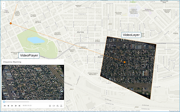
* The VideoLayer provides video content from on-demand and livestream feeds from an [ArcGIS Video Server](https://enterprise.arcgis.com/en/video/).
* Application developers using VideoLayer can display the video georeferenced on a [Map](https://developers.arcgis.com/javascript/latest/references/core/Map/), and control the playback with the [VideoPlayer](https://developers.arcgis.com/javascript/latest/references/core/widgets/VideoPlayer/) widget.
*
* > [!WARNING]
* >
* > **Known Limitations**
* >
* > Not supported in 3D [SceneViews](https://developers.arcgis.com/javascript/latest/references/core/views/SceneView/).
* > Not supported by the [Legend](https://developers.arcgis.com/javascript/latest/references/map-components/components/arcgis-legend/).
* > Not supported on macOS and iOS devices.
*
* 
*
* @since 4.30
* @example const videoLayer = new VideoLayer({ url });
*/
export default class VideoLayer extends VideoLayerSuperclass {
/**
* @example
* // Create a new VideoLayer instance referencing a video service
* const videoLayer = new VideoLayer({ url });
*/
constructor(properties?: VideoLayerProperties);
/**
* Indicates if the video layer is configured to start playback when ready.
*
* @default false
* @since 4.33
* @example
* // Configure the layer to start playback when ready
* videoLayer.autoplay = true;
*/
accessor autoplay: boolean;
/**
* Represents the length of the currently buffered video in seconds.
* The buffered time is updated as the video is played.
*/
get buffered(): number;
/**
* Represents available information about the sensor that captured the
* stream data. This property is mainly used in defining camera information
* from static sensors.
*
* @since 4.34
*/
get cameraInfo(): VideoCameraInfo | null | undefined;
/**
* The capabilities of the video layer.
* The capabilities describe the operations the video layer supports and are defined by the video service.
*/
get capabilities(): VideoLayerCapabilities | null | undefined;
/**
* Defines the codecs on the media content of the video layer. The
* codec for audio, text and video are defined on the video service
* during layer creation. Media type and formats are described in more
* detail [here](https://developer.mozilla.org/en-US/docs/Web/Media/Guides/Formats).
*
* @since 4.33
*/
get codecs(): Codecs | null | undefined;
/**
* The connection information for the video layer.
* The information includes the HTTP Live Streaming (HLS) connection URL for the video layer.
*
* @since 4.34
*/
get connectionInfo(): any | null | undefined;
/**
* The copyright information for the video layer.
*
* @example
* // Set the copyright
* videoLayer.copyright = "© 2024 Esri";
*/
accessor copyright: string | null | undefined;
/** The date the video layer was created. */
get created(): Date | null | undefined;
/** The current time of the video layer in seconds. */
get currentTime(): number;
/**
* The description of the video layer.
*
* @example
* // Set the description
* videoLayer.description = "This is a video layer";
*/
accessor description: string | null | undefined;
/** The duration of the video layer in seconds. */
get duration(): number;
/** Indicates if the video layer has ended and the [current time](https://developers.arcgis.com/javascript/latest/references/core/layers/VideoLayer/#currentTime) is equal to the [duration](https://developers.arcgis.com/javascript/latest/references/core/layers/VideoLayer/#duration) of the video. */
get ended(): boolean;
/**
* A [SimpleMarkerSymbol](https://developers.arcgis.com/javascript/latest/references/core/symbols/SimpleMarkerSymbol/) used for representing the center point of a video frame.
*
* @since 4.33
*/
get frameCenterSymbol(): SimpleMarkerSymbol;
set frameCenterSymbol(value: (SimpleMarkerSymbolProperties & { type: "simple-marker" }));
/** The total number of frames in the video layer. */
get frameCount(): number | null | undefined;
/**
* Provides filter functions that can be performed on the video frame to
* achieve different visual effects.
*
* @since 4.33
*/
accessor frameEffect: Effect | null | undefined;
/**
* The opacity of the video frame draped on the map. Value can be a number
* between `0` and `1` where `0` is 100% transparent, `0.5` is 50%
* transparent and `1` is fully opaque.
*
* @default 1
* @since 4.33
*/
accessor frameOpacity: number;
/**
* A [SimpleFillSymbol](https://developers.arcgis.com/javascript/latest/references/core/symbols/SimpleFillSymbol/) used for representing the coverage area of a video frame.
*
* @since 4.33
*/
get frameOutlineSymbol(): SimpleFillSymbol;
set frameOutlineSymbol(value: (SimpleFillSymbolProperties & { type: "simple-fill" }));
/**
* The full extent of the video layer.
*
* @example
* // Set the map view's extent to the full extent of the video layer
* await layer.load();
* view.goTo(layer.fullExtent);
* @example
* // Once the layer loads, set the view's extent to the layer's full extent
* layer.when(function(){
* view.extent = layer.fullExtent;
* });
*/
get fullExtent(): Extent | null | undefined;
set fullExtent(value: ExtentProperties | null | undefined);
/**
* The ground control points for the video layer.
* The ground control points are used to transform the video layer's pixel coordinates to ground coordinates.
* The `x` and `y` properties are measured in pixels from the top left corner of the video frame.
*
* @since 4.34
*/
get groundControlPoints(): VideoGroundControlPoint[] | null | undefined;
/**
* The initial extent of the video layer.
*
* @example
* // Set the map view's extent to the initial extent of the video layer
* await layer.load();
* view.goTo(layer.initialExtent);
*/
get initialExtent(): Extent | null | undefined;
set initialExtent(value: ExtentProperties | null | undefined);
/**
* The active stream is loaded as a livestream video layer
*
* @default false
* @since 4.33
*/
get isLive(): boolean;
/** The layer id of the video layer. */
get layerId(): number | null | undefined;
/**
* Provides status details about an ongoing livestream playback. This
* property is updated with each livestream time update.
*
* @since 4.34
*/
get livestreamStatus(): LivestreamStatus | null | undefined;
/**
* Indicates if the video layer should loop.
* If the video layer is set to loop, the video will restart from the beginning once it reaches the end.
* Otherwise, the video will stop playing once it reaches the end.
*
* @default false
* @example
* // Loop the video layer
* videoLayer.loop = true;
*/
accessor loop: boolean;
/**
* The metadata for the video layer.
* The metadata includes information such as the telemetry data, sensor model, and video frame information.
*/
get metadata(): Map<number, VideoMetadataEntry> | null | undefined;
/**
* Defines the mime type of the active playback source
*
* @since 4.33
*/
get mimeType(): string | null | undefined;
/**
* Indicates if the video layer is muted.
*
* @default false
* @example
* // Mute the video layer
* videoLayer.muted = true;
*/
accessor muted: boolean;
/**
* The playback information for the video layer.
* The playback information includes the framerate, container format, group of pictures (GOP), aspect ratio, and key length value (KLV).
*
* @since 4.33
*/
get playbackInfo(): PlaybackInfo | null | undefined;
set playbackInfo(value: PlaybackInfoProperties | null | undefined);
/**
* The playback rate of the video layer.
* The playback rate is the speed at which the video is played.
*
* @default 1
* @example
* // Set the playback rate of the video layer
* videoLayer.playbackRate = 2;
*/
accessor playbackRate: number;
/**
* The URL for use with the video player.
*
* @since 4.34
*/
get playerUrl(): string | null | undefined;
/**
* Indicates if the video layer is playing.
*
* @see [play()](https://developers.arcgis.com/javascript/latest/references/core/layers/VideoLayer/#play)
*/
get playing(): boolean;
/** The URL to the poster image for the video layer. */
get posterUrl(): string | null | undefined;
/**
* The available video qualities for the video layer.
*
* Quality | Resolution | Description
* --------|------------|------------
* sd | 720x480 | Standard Definition
* hd | 1280x720 | High Definition
* fhd | 1920x1080 | Full High Definition
* qhd | 2560x1440 | Quad High Definition
* uhd | 3840x2160 | Ultra High Definition
*/
get qualities(): VideoQuality[] | null | undefined;
/**
* A [SimpleLineSymbol](https://developers.arcgis.com/javascript/latest/references/core/symbols/SimpleLineSymbol/) used for representing the line of sight from the sensor to the center of the frame coverage area.
*
* @since 4.33
*/
get sensorSightLineSymbol(): SimpleLineSymbol;
set sensorSightLineSymbol(value: (SimpleLineSymbolProperties & { type: "simple-line" }));
/**
* A [SimpleMarkerSymbol](https://developers.arcgis.com/javascript/latest/references/core/symbols/SimpleMarkerSymbol/), [PictureMarkerSymbol](https://developers.arcgis.com/javascript/latest/references/core/symbols/PictureMarkerSymbol/) or [CIMSymbol](https://developers.arcgis.com/javascript/latest/references/core/symbols/CIMSymbol/) used for representing the point position geometry of the video sensor.
*
* The default sensor symbol is the following:
* ```js
* {
* type: "simple-marker",
* style: "circle",
* size: 16,
* color: [255, 127, 0],
* outline: {
* color: [255, 255, 255],
* width: 1.33
* }
* }
* ```
*
* @since 4.33
*/
get sensorSymbol(): SimpleMarkerSymbol | PictureMarkerSymbol | CIMSymbol;
set sensorSymbol(value: (SimpleMarkerSymbolProperties & { type: "simple-marker" }) | (PictureMarkerSymbolProperties & { type: "picture-marker" }) | (CIMSymbolProperties & { type: "cim" }));
/**
* Property is used to define orientation information to compute the
* display angle of the sensor location symbol. The symbol angle can be
* used to orient to the heading direction of the sensor platform, or to
* the camera azimuth of the recording sensor
*
* @default { source: "platformHeading", symbolOffset: 0 }
* @since 4.34
*/
accessor sensorSymbolOrientation: SensorOrientationInfo;
/**
* A [SimpleLineSymbol](https://developers.arcgis.com/javascript/latest/references/core/symbols/SimpleLineSymbol/) used for representing the trailing line of travel of a moving video collection sensor.
*
* @since 4.33
*/
get sensorTrailSymbol(): SimpleLineSymbol;
set sensorTrailSymbol(value: (SimpleLineSymbolProperties & { type: "simple-line" }));
/** The ArcGIS Enterprise Portal item id of the video service. */
get serviceItemId(): string | null | undefined;
/**
* The source quality of the video layer.
*
* Quality | Resolution | Description
* --------|------------|------------
* sd | 720x480 | Standard Definition
* hd | 1280x720 | High Definition
* qhd | 2560x1440 | Quad High Definition
* uhd | 3840x2160 | Ultra High Definition
*/
get sourceQuality(): VideoQuality | null | undefined;
/** The source type of the video layer. */
get sourceType(): VideoSourceType | null | undefined;
/**
* The spatial reference of the video layer.
*
* @default SpatialReference.WGS84
* @see [SpatialReference.WGS84](https://developers.arcgis.com/javascript/latest/references/core/geometry/SpatialReference/#WGS84)
* @example
* // Set the spatial reference of the video layer
* videoLayer.spatialReference = new SpatialReference({
* wkid: 4326
* });
*/
get spatialReference(): SpatialReference;
set spatialReference(value: SpatialReferenceProperties);
/**
* The playback start time in seconds since the beginning of the video.
*
* @default 0
* @since 4.33
*/
accessor start: number;
/**
* The layer play operation has been invoked at least one time.
*
* @default false
* @since 4.33
*/
get started(): boolean;
/** The current state of the video layer. */
get state(): VideoState | null | undefined;
/**
* The telemetry data for the video layer.
* The telemetry data is used to display the frame and sensor location on the map and is updated as the video is played.
*/
get telemetry(): TelemetryData;
/**
* The telemetry display for the video layer.
* The telemetry display is used to determine what [telemetry](https://developers.arcgis.com/javascript/latest/references/core/layers/VideoLayer/#telemetry) data to display on the video layer.
*
* @example
* // Display only the frame outline
* videoLayer.telemetryDisplay = new TelemetryDisplay({
* frame: false,
* frameCenter: false,
* frameOutline: true,
* lineOfSight: false,
* sensorLocation: false,
* sensorTrail: false,
* });
*/
get telemetryDisplay(): TelemetryDisplay;
set telemetryDisplay(value: TelemetryDisplayProperties);
/**
* The title of the layer used to identify it in places such as the [Legend](https://developers.arcgis.com/javascript/latest/references/map-components/components/arcgis-legend/)
* and [LayerList](https://developers.arcgis.com/javascript/latest/references/core/widgets/LayerList/).
*
* @example
* // Set the title of the video layer
* videoLayer.title = "My Video Layer";
*/
accessor title: string | null | undefined;
/** The layer type provides a convenient way to check the type of the layer without the need to import specific layer modules. */
get type(): "video";
/** The URL to the REST endpoint of the video service. */
accessor url: string | null | undefined;
/**
* The video service version of this layer.
*
* @since 4.33
*/
get version(): number | null | undefined;
/** The height of the video in pixels. */
get videoHeight(): number | null | undefined;
/**
* Defines layer information for video layers published within the same
* video service
*/
get videoLayersInfo(): VideoServiceLayerInfo[] | null | undefined;
/** The time extent of the video. */
get videoTimeExtent(): VideoTimeExtent | null | undefined;
/** The width of the video in pixels. */
get videoWidth(): number | null | undefined;
/**
* The volume property sets or returns the audio volume of a video, from 0.0
* (silent) to 1.0 (loudest). The default value is 0.0.
*
* @since 4.33
*/
accessor volume: number;
/**
* Indicates if the video layer is waiting for data.
* If `true`, the video layer is waiting for data; otherwise, it is not waiting for data.
*/
get waiting(): boolean | null | undefined;
/**
* Pauses the video layer.
*
* @example
* // Pause the video layer
* videoLayer.pause();
*/
pause(): void;
/**
* Plays the video layer.
*
* @example
* // Play the video layer
* videoLayer.play();
*/
play(): void;
/**
* Resets the video layer to its initial state.
*
* @example
* // Reset the video layer
* videoLayer.reset();
*/
reset(): void;
/**
* Sets the current time, in seconds, of the video layer.
*
* @param timestamp - The timestamp to set the video layer to.
* @example
* // Set the current time of the video layer to 30 seconds
* videoLayer.setCurrentTime(30);
*/
setCurrentTime(timestamp: number): void;
/**
* Updates the telemetry color of all telemetry symbol elements to the provided color value.
*
* @param color - The color to set the video telemetry symbol color to.
* @example
* // Set the telemetry color to red
* videoLayer.updateTelemetryColor(new Color("red"));
*/
updateTelemetryColor(color: Color): void;
}
declare const VideoLayerSuperclass: typeof Layer & typeof CustomParametersMixin & typeof MultiOriginJSONSupportMixin & typeof PortalLayer & typeof OperationalLayer & typeof ScaleRangeLayer & typeof BlendLayer
/** The **VideoPoint** is an object that represents a point on the current video frame. */
export interface VideoPoint {
/** The x coordinate on the current video frame in pixels from the top left corner */
x: number;
/** The y coordinate on the current video frame in pixels from the top left corner */
y: number;
}