@arcgis/core
Version:
ArcGIS Maps SDK for JavaScript: A complete 2D and 3D mapping and data visualization API
169 lines (167 loc) • 9.4 kB
TypeScript
import type Point from "../../Point.js";
/**
* The Transformation class represents 2D transformations that can be applied to geometries using the [affineTransformOperator](https://developers.arcgis.com/javascript/latest/references/core/geometry/operators/affineTransformOperator/). All transformations are applied in the spatial reference units of the input geometries.
*
* @since 4.31
*/
export default class Transformation {
constructor();
/**
* Calculates distance errors for a transformation on a given set of the input points to the output points.
* This method is usually used to calculate errors for the transformation initialized by [initializeFromControlPoints()](https://developers.arcgis.com/javascript/latest/references/core/geometry/operators/support/Transformation/#initializeFromControlPoints).
*
* The length of the `input` and `output` arrays must be the same.
*
* @param input - The input points to transform from.
* @param output - The output points to transform to.
* @returns Returns an object representing the errors incurred during transformation.
* @example
* // Calculate the errors for a transformation
* const errors = transformation.calculateErrors(inputPoints, outputPoints);
* // Example returned object:
* // { rms: 0.5, errorsOut: [0.1, 0.2, 0.3, 0.4, 0.5] }
*/
calculateErrors(input: Point[], output: Point[]): ErrorResult;
/**
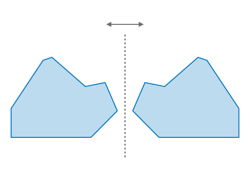
* Flips all the `x` coordinates of geometries on the vertical y-axis (right or left) that is centered between `x0` and `x1`.
* For example, if `x0` is 0 and `x1` is 10, all the `x` coordinates of the geometries will be flipped, or mirrored, on the vertical axis centered at `x = 5`.
*
* 
*
* @param x0 - The x-coordinate of the first geometry.
* @param x1 - The x-coordinate of the second geometry.
* @example
* // Flip the x-coordinates of a geometry on the vertical axis
* const transform = new Transformation();
* transform.flipX(0, 10);
* const result = affineTransformOperator.execute(polygon, transform);
*
* // Flip the x-coordinates of a geometry on the vertical axis centered at the geometry's center
* const centerX = polygon.extent.center.x;
* transform.flipX(centerX, centerX);
* const result = affineTransformOperator.execute(polygon, transform);
*/
flipX(x0: number, x1: number): this;
/**
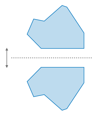
* Flips all the `y` coordinates of geometries on the horizontal x-axis (up or down) that is centered between `y0` and `y1`.
* For example, if `y0` is 0 and `y1` is 10, all the `y` coordinates of the geometries will be flipped, or mirrored, on the horizontal axis centered at `y = 5`.
*
* 
*
* @param y0 - The y-coordinate of the first geometry.
* @param y1 - The y-coordinate of the second geometry.
* @example
* // Flip the y-coordinates of a geometry on the vertical axis
* transformation.flipY(0, 10);
* const result = affineTransformOperator.execute(polygon, transform);
*
* // Flip the y-coordinates of a geometry on the horizontal axis centered at the geometry's center
* const centerY = polygon.extent.center.y;
* transform.flipY(centerY, centerY);
* const result = affineTransformOperator.execute(polygon, transform);
*/
flipY(y0: number, y1: number): this;
/**
* Initializes a new transformation from the input and output control points.
* Uses least squares method to find the best fit transformation.
* Adding control points allows you to snap lines and polygons to the input and output points on a map.
*
* The length of the `input` and `output` arrays must be the same.
*
* @param type - The type of transformation to initialize.
*
* Value | Description
* ------|------------
* "conformal" | Preserves the angles between curves.
* "general" | Preserves lines and parallelisms. Does not preserve angles or lengths.
* @param input - The input points to transform from.
* @param output - The output points to transform to.
* @param inverseOut - The transformation instance that is the inverse of the calculated transformation.
* @example
* // Initialize a transformation from control points
* transformation.initializeFromControlPoints("conformal", inputPoints, outputPoints);
*/
initializeFromControlPoints(type: "conformal" | "general", input: Point[], output: Point[], inverseOut?: Transformation): void;
/**
* Determines if the transformation is in its default state, which is an identity matrix.
*
* @returns Returns `true` if the transformation is the default and has not been changed.
* There will be no change in the geometries when applying the transformation.
* @see [setIdentity()](https://developers.arcgis.com/javascript/latest/references/core/geometry/operators/support/Transformation/#setIdentity)
*/
isIdentity(): boolean;
/**
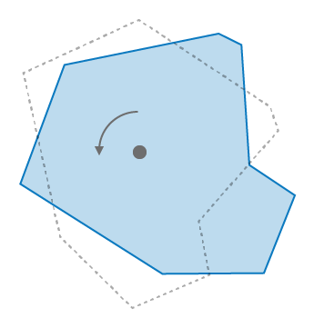
* Rotates the geometries by the specified angle in degrees around the point specified by the x and y coordinates.
* The point can be the center of the geometries or any other point.
*
* 
*
* @param angleInDegrees - The angle to rotate the geometries in degrees.
* @param rotationX - The x-coordinate of the point to rotate around.
* @param rotationY - The y-coordinate of the point to rotate around.
* @example
* // Rotate a geometry
* transformation.rotate(90, 0, 0);
* const result = affineTransformOperator.execute(polygon, transform);
*/
rotate(angleInDegrees: number, rotationX?: number, rotationY?: number): this;
/**
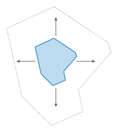
* Resizes the geometries by the specified scale factors defined by the x and y coordinates.
* The coordinates define how much scaling is applied to the geometries in the x and y directions.
*
* 
*
* @param x - The x-coordinate that defines the horizontal scale factor.
* @param y - The y-coordinate that defines the vertical scale factor.
* @example
* // Scale a geometry
* transformation.scale(2, 2);
* const result = affineTransformOperator.execute(polygon, transform);
*/
scale(x: number, y: number): this;
/**
* Use this method to reset the transformation to its default state, which is an identity matrix.
* This method is useful when reusing the class instance for multiple transformations.
*
* @see [Wikipedia - Identity Matrix](https://en.wikipedia.org/wiki/Identity_matrix)
*/
setIdentity(): void;
/** Use this method to swap the x and y coordinate values in the transformation. An example usage is when slicing vertically with the [polgonSlicerOperator.findSlicesByArea()](https://developers.arcgis.com/javascript/latest/references/core/geometry/operators/polygonSlicerOperator/#findSlicesByArea) method. */
setSwapCoordinates(): this;
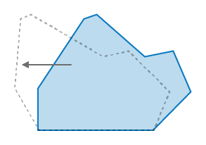
/**
* Shifts a geometry's points by the specified proportion in parallel to the x and y directions,
* except those points that are along the shear axis, which is a line defined by the x and y coordinates.
* This transformation preserves lines and parallelisms, however it may distort angles and distances.
* Applying this transformation will not change a geometry's area.
*
* 
*
* @param proportionX - The proportion to shear the geometry in the x direction.
* @param proportionY - The proportion to shear the geometry in the y direction.
* @example
* // Shear a geometry
* transformation.shear(0.5, 0.5);
* const result = affineTransformOperator.execute(polygon, transform);
*/
shear(proportionX: number, proportionY: number): this;
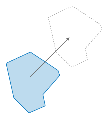
/**
* Shifts all the coordinates of the geometries by the distance and direction between the specified `x` and `y` coordinates and their current location. This operation does not change the size or shape of the geometries.
*
* 
*
* @param x - The x-coordinate to shift by.
* @param y - The y-coordinate to shift by.
* @example
* // Shift the coordinates of a geometry
* transformation.shift(5, 2);
* const result = affineTransformOperator.execute(polygon, transform);
*/
shift(x: number, y: number): this;
}
/** Object returned from the [calculateErrors()](https://developers.arcgis.com/javascript/latest/references/core/geometry/operators/support/Transformation/#calculateErrors) method. */
export interface ErrorResult {
/** The root mean square (`rms`) of the 'average' distance error between the specified `output` points and the transformed `input` points. */
rms: number;
/** Contains the errors of the individual distance differences between specific pairs of points. */
errorsOut: number[];
}